# The Center for Spatial Technologies (CST) — Full Content
> Complete markdown content of all published research projects in English and Ukrainian.
> For a structured index, see [llms.txt](https://spatialtech.info/llms.txt).
---
## Church, Chora, Chersonese
- URL: https://spatialtech.info/en/works/chersonese
- Language: English
- Date: 2025-06-21T00:00:00.000Z
- Category: Installation, media, archaeology, cultural heritage


Church, Chora, Chersonese — a two-screen video installation by the Center for Spatial Technologies (CST) — premiered at Jam Art Center, Lviv, as part of [The Stammering Circle](https://jamfactory.ua/en/projects/the_stammering_circle/), an exhibition curated by Marta Kuzma. The work was co-commissioned in 2025 by [Faktura 10](https://faktura10.org), a program of RIBBON International, and by [BAK, basis voor actuele kunst](https://www.bakonline.org), Utrecht.
Drawing on maps, excavation plans, wartime reconnaissance photographs, newsreels, and contemporary footage, the installation follows three spatial protagonists: Church (sacred architecture), Chora (agricultural hinterland), and Chersonese (walled city). From the first imperial digs of the late 1700s through Soviet and Nazi surveys to Russia’s current occupation of Crimea, CST shows how archaeology is repeatedly conscripted to serve territorial claims, forging a durable alliance of military power, sacred architecture, and heritage science. The synchronised, looping screens invite viewers to read laterally across media and centuries, revealing how each “objective” layer of evidence overwrites its predecessor to legitimise new regimes.
---
## Храм, Хора, Херсонес
- URL: https://spatialtech.info/uk/works/chersonese
- Language: Ukrainian
- Date: 2025-06-21T00:00:00.000Z
- Category: Інсталяція, медіа, археологія, культурна спадщина


«Храм, Хора, Херсонес» — двоекранна відеоінсталяція Центру просторових технологій (CST), уперше представлена у Jam Art Center у Львові в межах виставки _The Stammering Circle_ (кураторка — Марта Кузьма). Роботу cтворено 2025 року на спільне замовлення [Faktura 10](https://faktura10.org) (ініціатива організації RIBBON International) та [BAK, basis voor actuele kunst](https://www.bakonline.org) (Утрехт).
Спираючись на карти, плани розкопок, воєнні аерофотознімки, кіножурнали й сучасні кадри, інсталяція простежує трьох просторових «персонажів»: Храм (сакральна архітектура), Хора (сільськогосподарська округа) та Херсонес (обнесене стінами місто). Від перших імперських розкопок наприкінці XVIII століття через радянські й нацистські дослідження до теперішньої російської окупації Криму CST показує, як археологія раз по раз стає інструментом територіальних претензій, утворюючи стійкий союз військової сили, сакральної архітектури та науки про спадщину. Синхронізовані, циклічні екрани спонукають глядачів читати події крізь різні медіа й століття, відкриваючи, як кожен «об’єктивний» шар доказів нашаровує попередній, щоб легітимізувати нові режими.
---
## Mariupol Drama Theater
- URL: https://spatialtech.info/en/works/mariupol-drama-theater
- Language: English
- Date: 2024-03-16T00:00:00.000Z
- Category: Spatial reconstruction, history and culture
**Spatial reconstruction, history and culture**
This study reconstructs the Mariupol Drama Theater, exploring how it became a symbol of civilian resistance and solidarity amidst devastating war, and, at the same time, of Russia's strategies of terror. By gathering photographs, videos, spatial models, and eyewitness accounts, we aim to preserve the theater's cultural legacy and contextualize this historic event.
**Date:** March 16, 2024
**Location:** Mariupol, Ukraine
**Category:** Reconstruction
[Visit Project →](https://theater.spatialtech.info/)
---
## Маріупольський драматичний театр
- URL: https://spatialtech.info/uk/works/mariupol-drama-theater
- Language: Ukrainian
- Date: 2024-03-16T00:00:00.000Z
- Category: Просторова реконструкція, історія та культура
# Маріупольський драматичний театр
**Просторова реконструкція, історія та культура**
Цей проєкт досліджує російську атаку на Маріупольський драмтеатр, що стала символом російського терору. Наша мета — в одному просторі зібрати розрізнені голоси свідк_инь цієї трагедії та підсилити їх матеріалами дослідження.
**Дата:** Mar 16, 2024
**Локація:** Маріуполь, Україна
**Категорія:** Реконструкція
[Перейти до проєкту →](https://theater.spatialtech.info/)
---
## Nebelivka Hypothesis
- URL: https://spatialtech.info/en/works/nebelivka
- Language: English
- Date: 2023-05-18T00:00:00.000Z
- Category: archaeology, history, and cities

In the depths of the black soil of central Ukraine, settlements from a 6000-year-old past were discovered. They are comparable in size and antiquity to the earliest Mesopotamian cities but were created on entirely different principles. These findings can change our understanding of the historical perspective on city construction and challenge traditional notions of civilization evolution.
The Nebelivka research demonstrates that Ukrainian proto-cities were organized as concentric rings of houses around a mysterious open space. The study of landscapes in central Ukraine began in the 1970s, and it was during this time that archaeologists discovered eleven settlements from the 6000-year-old past, each consisting of residential buildings arranged in a ring, encompassing a vast open territory.

Artifacts provide an opportunity to look at urban space differently, indicating that early cities did not require a hierarchical form and structure. There were no traces of palaces, administrations, rich burials, or any other signs of centralized control or social stratification. Material evidence indicates the need for a critical rethinking of the origins and possibilities of cities and traditional concepts of urban space, power, and ecology. The Nebelivska hypothesis asserts that egalitarian societies existed on an urban scale; and that cities can also enhance the viability of the land they inhabit.
The CST team set off to Nebelivka to gather stories from farmers living and working in the ancient city site and create three-dimensional landscape models.
Materials prepared by the Center for Spatial Technologies have been included in the multimedia installation exhibition by Forensic Architecture at the 18th Architecture Biennale in Venice. Publication with research for the installation is available at the following link: [https://content.forensic-architecture.org/wp-content/uploads/2023/04/The-Nebelivka-Hypothesis_FA-Wengrow_Book.pdf](https://content.forensic-architecture.org/wp-content/uploads/2023/04/The-Nebelivka-Hypothesis_FA-Wengrow_Book.pdf)
---
## Nebelivka Hypothesis
- URL: https://spatialtech.info/uk/works/nebelivka
- Language: Ukrainian
- Date: 2023-05-18T00:00:00.000Z
- Category: Археологія, історія та міста

У глибинах чорноземів центральної України були виявлені поселення 6000-річної давнини, чий рівень розвитку та період існування збігається із першими месопотамським містам, але створені на зовсім інших принципах. Знахідки здатні змінити погляд на історичну перспективу побудови міст та піддати сумніву традиційні уявлення про еволюцію цивілізації.
Дослідження Небелівки демонструє, що протоміста на території сучасної України були організовані у вигляді концентричних кілець будинків, які базувалися навколо таємничого відкритого простору. Про залишки цих міст було відомо ще в кінці 18-ого століття, проте археологи не припускали що знайдені артефакти належать окремим мегапоселенням з виразною структурою концентричних кіл. У 1970-х роках — саме тоді археологи виявили одинадцять поселень 6000-річної давнини[^1], кожне з яких налічувало житлові будівлі, збудовані кільцем, що охоплювали величезну відкриту територію.

Знахідки з Небелівки та інших мегапоселень дають можливість по-іншому поглянути на міський простір, вказуючи на те, що ранні міста не потребували ієрархічної форми та структури. Під час розкопок тут не було знайдено слідів палаців, адміністративних будівель, поховань з коштовностями, чи будь-яких інших ознак централізованого контролю, чи соціальної стратифікації. Це вказує на необхідність критичного переосмислення традиційних уявлень про міський простір, його ієрархію, взаємозв'язок з владою та екологією. Небелівська гіпотеза стверджує, що егалітарні суспільства існували в міському масштабі ще 6000 років тому, залишивши після себе збагачений ґрунт і відсутність будь-яких слідів шкоди навколишньому середовищу.
Команда CST вирушила в Небелівку, щоб зібрати історії фермерів, що живуть і працюють на території одного зі стародавніх протоміст та виробити тривимірні моделі місцевого ландшафту.
Читати детальніше про проєкт:
[https://content.forensic-architecture.org/wp-content/uploads/2023/04/The-Nebelivka-Hypothesis_FA-Wengrow_Book.pdf](https://content.forensic-architecture.org/wp-content/uploads/2023/04/The-Nebelivka-Hypothesis_FA-Wengrow_Book.pdf)
---
[^1]: Шишкін К. В.. З практики дешифрування аерофотознімків в археологічних цілях, с. 36, Видавництво “Наукова Думка”, Київ — 1973
---
## Russian Attack on Kyiv TV Tower
- URL: https://spatialtech.info/en/works/tv-tower
- Language: English
- Date: 2022-06-10T00:00:00.000Z
- Category: Digital project of reconstruction

On 1 March 2022, Russia launched a missile strike on the Kyiv TV tower. It was not particularly effective militarily, nor was it among the deadliest strikes in Russia’s attack on Ukraine. However, the significance of targeting the capital city’s main television and radio tower cannot be underestimated, especially in a war that is as much about control over narrative as over land and the people inhabiting it.
The missiles targeting the TV tower landed on the territory known as Babyn Yar, the site of one of the worst massacres of the Holocaust. Historical references, particularly ones related to the Second World War and the Holocaust, have been continuously weaponised as part of Russia’s propaganda machine. Given their claims about the ‘de-Nazification’ of Ukraine, the damaging of one of the Holocaust’s most significant symbols, is particularly ironic.
Our investigation seeks to examine the confluence of past and present in this fraught landscape, drawing together a detailed analysis of the recent strike on the TV tower and a spatial reconstruction of the Babyn Yar site—a complex ravine system that used to run through this part of Kyiv. By excavating the historical layers of the Babyn Yar site, we have been able to locate within it the massacres that took place and the multiple attempts made to silence their memory.
## First missile
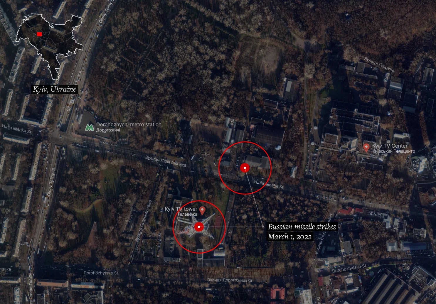
Shortly after 5 pm on 1 March, a missile hit the capital’s main radio and TV tower, exploding just below the control room. It was captured on video in mid-flight by numerous sources. Using these videos, we were able to calculate the size of the projectile relative to the tower, and through consultation with munitions specialists concluded that it was likely to be an air-launched cruise missile, such as the [3M-54 Kalibr](https://en.wikipedia.org/wiki/3M-54_Kalibr). We then synchronised multiple videos of the attacks by comparing the light and smoke plume from the explosion, which allowed us to determine the exact time of the first strike to be 17:08 EET. The TV tower withstood this first explosion. [According to media outlet France 24](https://www.france24.com/en/live-news/20220301-five-killed-in-russian-strike-on-kyiv-tv-tower), most channels hosted in the tower were back on the air about an hour after the strike. A nearby building caught on fire.

## Second missile
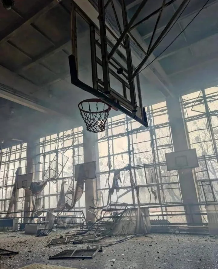
At 17:19, a second strike followed, passing close to the TV tower, seemingly missing it, and landing close to a Soviet-era building 200 metres away from the tower, across Illienka Street. The building, which is part of the [Avangard Sports Complex](https://avangardsport.com/), sustained significant structural damage. This structure had been due for renovation by the [Babyn Yar Holocaust Memorial Center](https://babynyar.org/) to host the new Museum of Holocaust in Ukraine and Eastern Europe. The Ukrainian police confirmed that Yevhenii Sakun, who worked for the media channel LIVE TV, was killed along with four others. Five more people were wounded.

## Attacks on civilian communication infrastructure
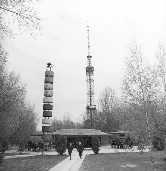
The Kyiv TV tower was reportedly used by a wide range of civilian TV and radio stations such as public TV channel UA Pershiy, the privately-owned TV channel 1+1, and the news channel Ukraine 24. At 385 metres high, the tower is the tallest structure in Ukraine and the tallest free-standing lattice structure in the world. It was designed by Kyiv-based V.N. Shimanovsky Ukrainian Institute of Steel Construction and erected in 1973.
Due to the unique upbuilding method used in its construction and its monumental height, it is included in The State Register of Monuments of Ukraine, which designates it a landmark with cultural heritage status.
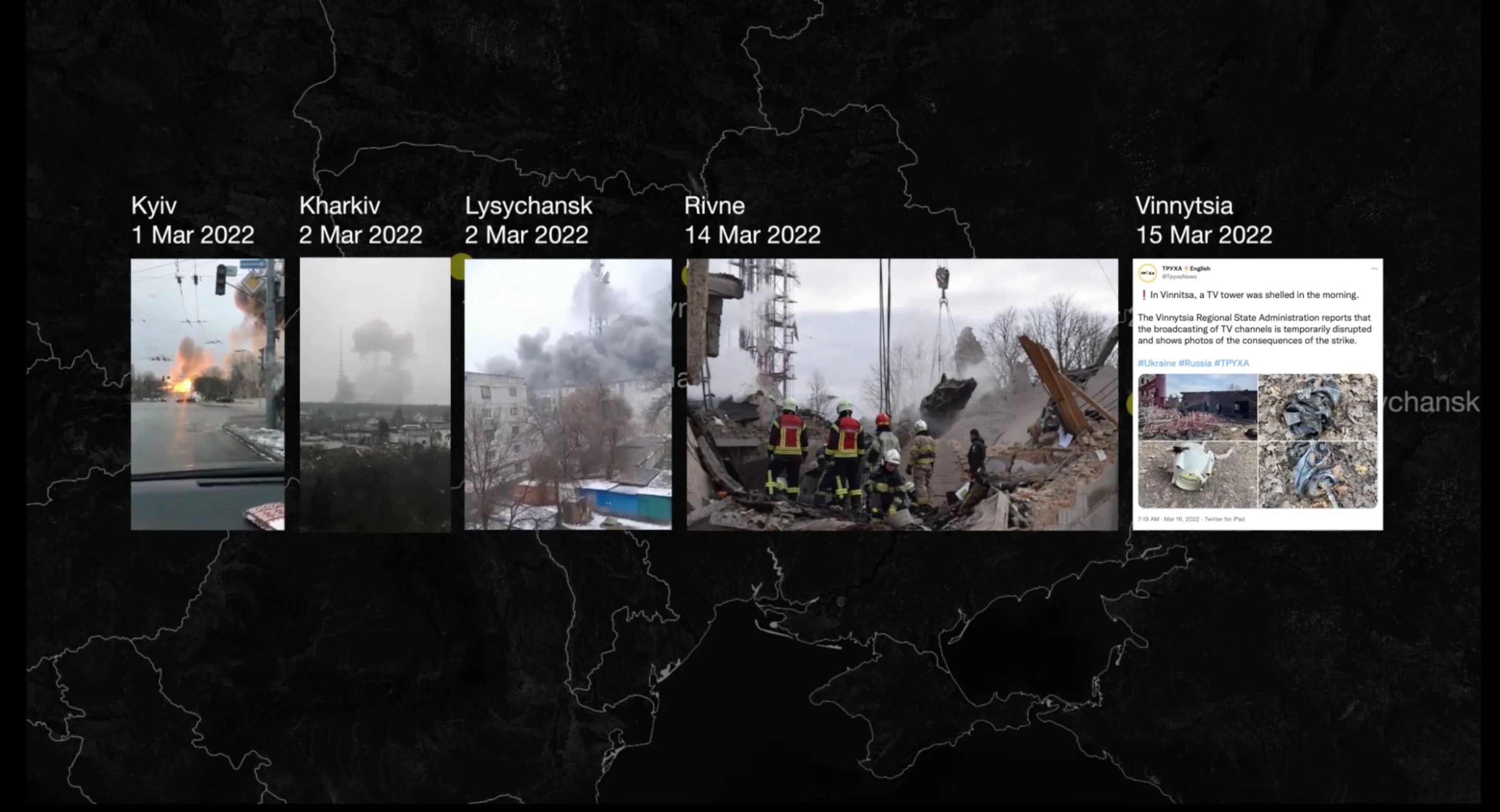
The Ukrainian NGO [Institute for Mass Information](https://imi.org.ua/monitorings/rosiya-skoyila-148-zlochyniv-proty-zhurnalistiv-ta-media-v-ukrayini-za-misyats-%20napadu-i44595) recorded at least ten Russian attacks on TV towers throughout Ukraine between 24 February and 24 March. TV towers in Kharkiv and Lysychansk were hit on 2 March, the day following the attacks in Kyiv, and further towers were targeted on 14 March in Rivne and on 15 March in Vinnytsia. In total, at least 32 TV channels and several dozen radio stations were affected over a one month period.
According to the Berlin-based European Center for Constitutional Human Rights (ECCHR), these systematic raids on the civilian communication infrastructure in Ukraine point to the Russian armed forces’ objective to disrupt the spread of information and demoralise the population.
On Tuesday, 1 March 2022, five days before the strike on the Kyiv TV tower, the Russian Defence Ministry warned that it planned to strike technological objects in Kyiv [to prevent ‘informational attacks’ against Russia](https://www.youtube.com/watch?v=Itfri6mpLGY&t=261s&ab_channel=%D0%A2%D0%B5%D0%BB%D0%B5%D0%BA%D0%B0%D0%BD%D0%B0%D0%BB6%D0%A2%D0%92).
There is no evidence to indicate that the damaged TV tower and adjoining technical buildings were being used for any military objectives. In its assessment of the attack, ECCHR confirmed that the TV tower was neither a military object nor a dual-use object, meaning that there was no lawful basis for the Russians to target it.
The open admission from the Russian Defence Ministry that forthcoming strikes were intended to thwart ‘informational attacks’, and the subsequent enactment of these threats through a pattern of attacks against civilian communications infrastructure, makes evident that the ECCHR’s assessment was correct, and reveals Russia’s strategic focus on supporting its disinformation efforts by attempting to eliminate voices that contradict its messaging.
As to the legitimacy of this defense, examining relevant legal precedents, ECCHR reviewed the International Criminal Tribunal for the former Yugoslavia (ICTY)’s legal opinion regarding the NATO strike in 1999 on Belgrade’s Avala tower — another culturally significant TV tower, which supported the operation of Serbian TV and radio channels. [In their statement](https://www.icty.org/x/file/Press/nato061300.pdf), the ICTY insisted that ‘civilians, civilian objects, and civilian morale as such are not legitimate military objectives’. The ICTY also stressed that although the media may disseminate propaganda, this does not make its operations a legitimate military target.
## Historical strata
The illegal nature of a strike on a communication tower is compounded by the fact that both the tower itself and the site on which it stands are sites of cultural heritage.
The strike on the TV tower and Babyn Yar territory has led to condemnation from political figures all over the world, including President Zelensky, who [tweeted](https://twitter.com/ZelenskyyUa/status/1498697538085568514?s=20&t=zNyWPac6ACGSyttRNrZFng) that it negated the post-Second World War promise ‘never again’.
The strike aimed at the Ukrainian media networks hit a tangled nervous system of historical references and repressed memories. Both missiles landed in close proximity to what used to be Babyn Yar ravine (‘yar’ is a ravine in Ukrainian and Russian).
Like needle probes, these missiles pierced through layers of historical strata, resulting in a spatial and temporal collision between the events of the current war and the site's deeply rooted history.
Between 15 February 2020 and 24 February 2022, The Center for Spatial Technologies undertook a commission from the Babyn Yar Holocaust Memorial Center to spatially investigate and digitally reconstruct the original topography of the Babyn Yar site.
Because both the genocide and its cover-up altered the topographical feature of the ravine, CST’s investigation afforded special attention to precisely modeling the landscape of the site across different periods in its history.
The landscape model was built by drawing from a combination of old topographic maps from the early 20th century, aerial images, and archival photographs that offered information about distinct features of the terrain from the beginning of the 20th century until the site was filled in and smoothed over in the 1950s.

## Reading the landscape
Both of the missiles landed on parts of the Babyn Yar territory where former cemeteries were located, as indicated by an allotment map from the late nineteenth century (see Fig. VIII).
The TV tower, hit in the first missile strike, stands on the ground of a former Russian Orthodox cemetery. The second strike hit what had been a Jewish cemetery, which also included sections for Muslims and Crimean Karaites, attesting to the rich cosmopolitan character of Kyiv at that time.
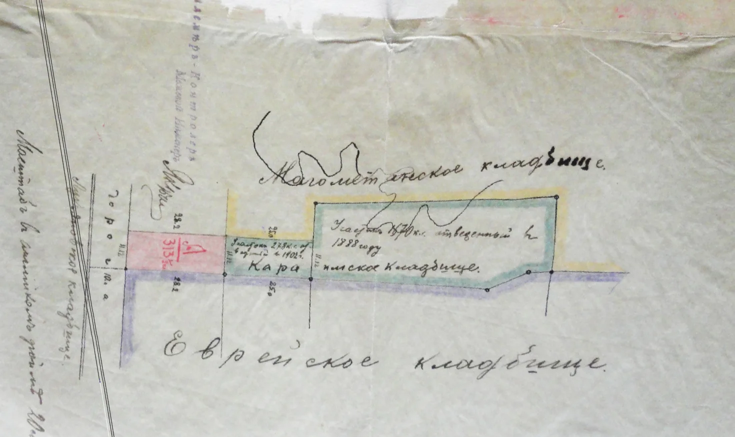
The official allocation of land for a new Jewish cemetery came about as a result of a decision from the Kyiv City Duma in March 1891. The following year, the famous Kyiv-born architect Volodymyr Nikolayev drew up plans for the layout of alleys in the burial grounds, as well as the creation of a brick wall with a gate and three auxiliary buildings.
At the turn of the 19th and 20th centuries, the territory of the cemetery was significantly expanded. By the end of the 1920s, the cemetery had reached capacity. During the 1930s, the state policy of persecution of religion in the USSR led to the vast majority of burials being deprived of religious rites and placement. In 1937 the cemetery was closed, and Jews were buried in various cemeteries around the city.
Figure IX. The two strikes hit former cemeteries. This map is based on an overlay of a cemetery land allotment map from the late 19th century and an aerial photograph from 1944.
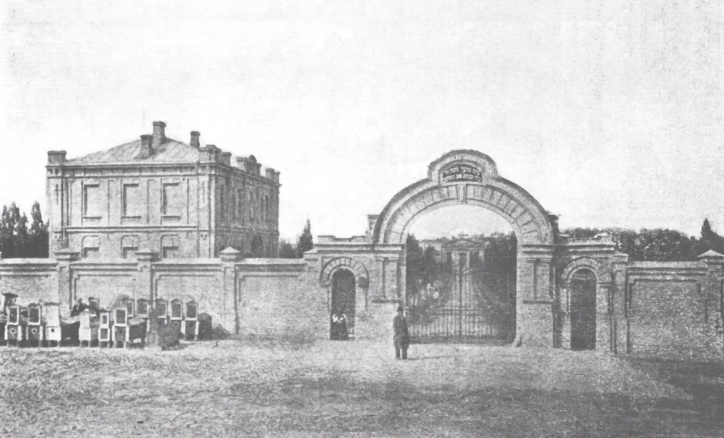
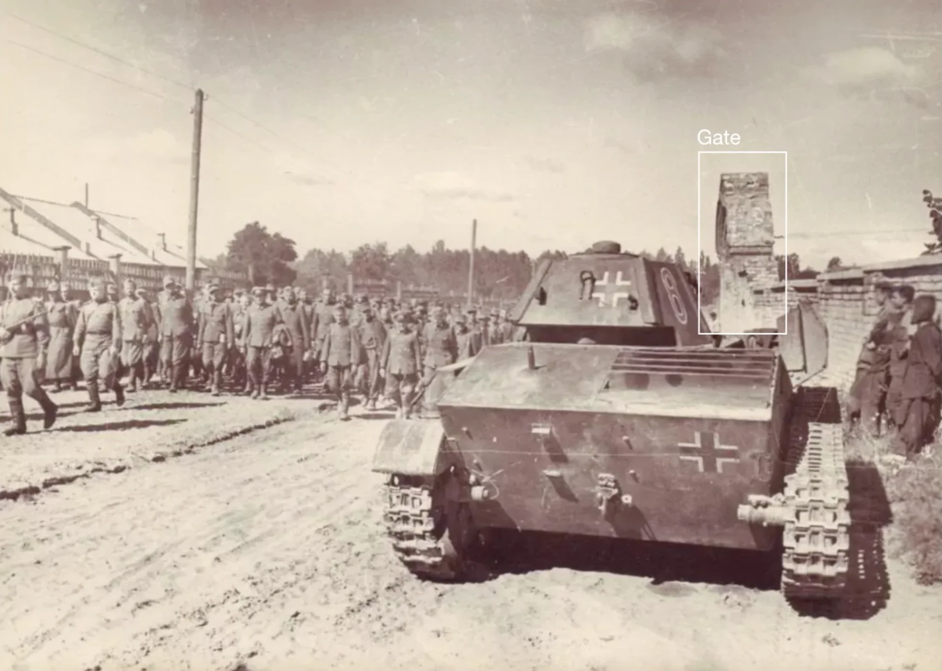
The gate of the aforementioned Jewish cemetery appears in the background of a piece of CCTV footage that captured the strike on the TV tower, allowing us to place it within the Babyn Yar site. The same gate appears in a photograph from the summer of 1944, in which Soviet troops are seen leading German prisoners of war.

That same year and the year prior, the area around Babyn Yar ravine was photographed from the air by the Germans for intelligence gathering purposes. Analysis of these aerial images reveals anti-aircraft guns abandoned on the ground and artillery craters, traces of the Soviet recapture of the city from the Germans. These craters (marked in Fig. XIII) were directly adjacent to the site of the Russian strike on the Kyiv TV tower. Here we see Russian missiles targeting the same Ukrainian territory where almost eighty years ago, as part of the Soviet army, Russians and Ukrainians were together battling the German occupiers of Kyiv
Figure XIII. An aerial photograph from 1944 shows anti-aircraft guns and craters in the same location as the airstrikes in March 2022.
## The massacres of Babyn Yar
## The massacres of Babyn Yar
CST’s digital reconstructions of Babyn Yar made it possible for the first time to geolocate a series of historical photographs within the landscape, yielding new information about the function of different areas of the site and the changes to its topography caused by repeated efforts to eliminate evidence of the crimes committed there.
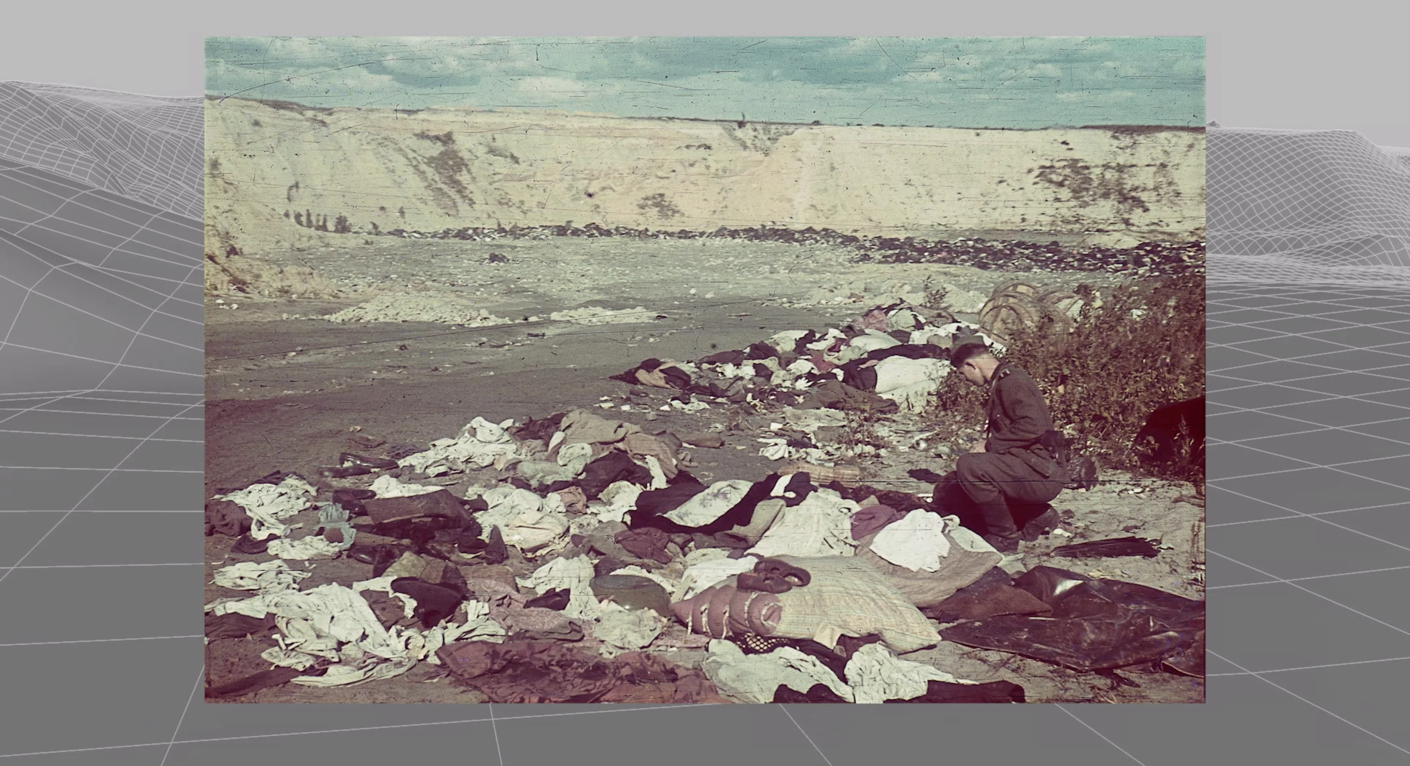
Using their topographic models, CST was able to identify the exact sites of the mass executions, as well as those secondary sites where various phases of the process leading up to them were carried out, including areas where the victims were ordered to deposit their belongings and strip their clothes.
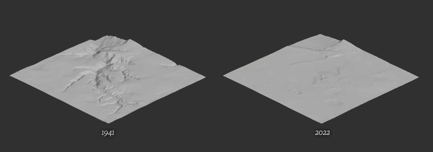

Throughout the occupation of Kyiv between 1941 and 1943, approximately 100,000 people — Jews, Ukrainian political prisoners, Romas, Soviet prisoners of war, and psychiatric patients — were systematically murdered on the territory of Babyn Yar.
The first and best documented of the massacres—and also one of the first and deadliest mass shootings of the Holocaust — took place in the westernmost spur of Babyn Yar ravine over two days, on 29 and 30 September 1941. Over 33,000 Jews were killed by members of Einsatzgruppe C (task Force C), one of the German ‘death squads’ formed after the invasion of the Soviet Union. These units were made up of members of the SS, security officers and ordinary policemen. Under the command of Reichsführer-SS Heinrich Himmler, this group, was explicitly tasked with murdering communist officials and Jews in the occupied Soviet territories. Under German command, local collaborators assisted in various tasks.
The process of mass murder began at the cemetery gate on the northwestern edge of Kyiv, where the Jews of Kyiv were ordered to gather. As they approached the intersection of Dorohozhytska and Sim'i Khokhlovykh streets, they were forced to leave their coats and luggage on the roadside.
Figure XVI shows the location where they surrendered their luggage, just 280 meters from the present location of the TV tower.
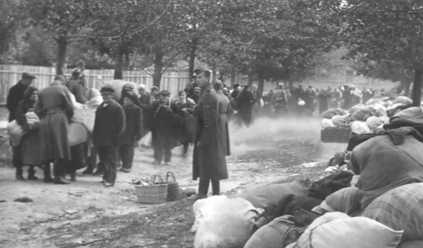
The victims were then led to a former sand quarry, dug up in the late 1930s right between two large branches of the ravine system, on the western part of it. There they were asked to undress in full, and taken in groups to the westernmost branch of the ravine.
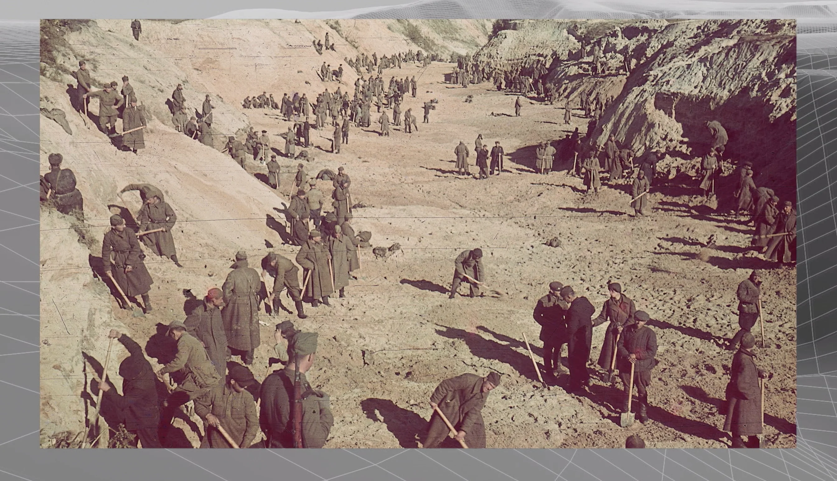
In this ravine, members of Einsatzgruppe C ordered the victims to lay on the ground or on top the bodies of the already murdered before being shot themselves. Witness testimonies mention six to seven layers of human bodies laid one on top of another.
While we know the 1941 mass execution of Jewish civilians took place in Babyn Yar, the exact locations of the majority of the other executions that followed are still unknown. Those executions could potentially have taken place within any number of other areas in the Babyn Yar site, particularly other branches of the ravine. As such, we cannot rule out that the branch extending just metres west of the sports complex might have been a site of some of these executions. This possibility is reinforced by its proximity to a main road (we know that these subsequent smaller-scale executions were carried out systematically, often several times a week, with victims summoned to the site or transported in vehicles).
In light of these unknowns, there is no one singular Babyn Yar Memorial—rather, the efforts thus far to construct one has been a multi-part work-in-progress that features a number of structures, monuments and interventions throughout the site. It is worth noting that not only do these execution sites remain unmarked, but so too are the sites upon which the ugly mechanisms of murder took place—namely, the systematic approach to the degradation and elimination of people—thus rendering the entirety of the Babyn Yar terrain deserving of memorial status.
## Erasure of evidence
In 1943, as the Soviets advanced on Kyiv, the Germans ordered prisoners incarcerated in the Syrets concentration camp to dig up and incinerate the human remains of those murdered in Babyn Yar.

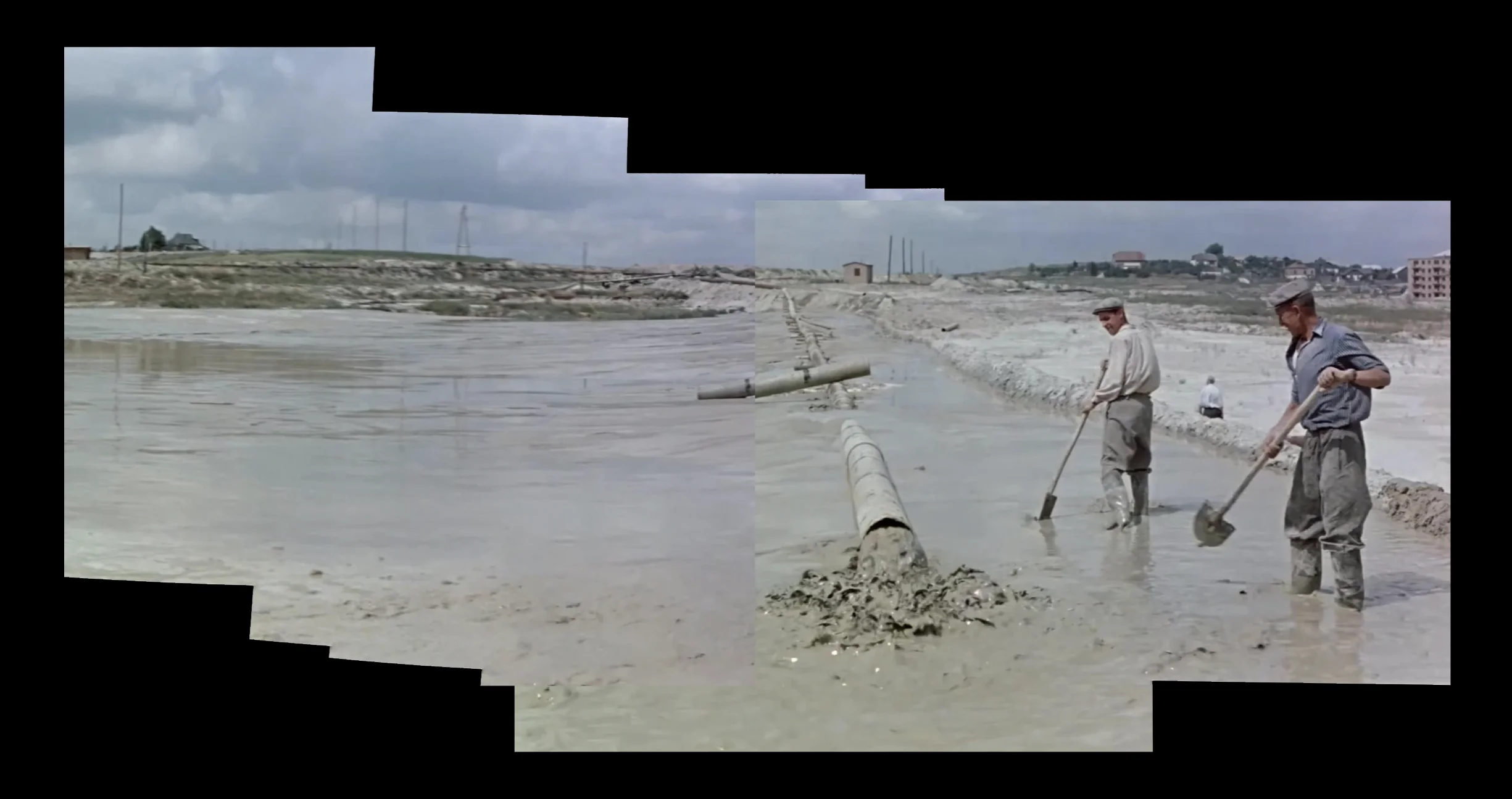
In 1951, eight years after the Germans left Kyiv, and six years after the end of the war, Soviet authorities ordered that the ravines be filled with liquid mud, a byproduct of brick production from a factory nearby, further flattening the topography of the site. Their stated motivation was to enable the growth of the city over the ravines and former cemeteries, but the erasure of the site of commemoration was also in line with the Soviet politics of memory that sought to undo the difference between different national tragedies and erase rather than face these dark blemishes upon the past.
Documents about the massacre were also classified, and activists seeking commemoration were prosecuted.
## Afterword
With our analysis, we seek to establish a clear evidentiary record of the destruction and casualties brought about by the Russian strike on the Kyiv TV tower. Drawing upon the CST’s work, this report also addresses the history of violence and genocide that occurred on this site over the past century, now buried under layers of earth and rubble but brought once more to the surface by this recent attack.
With the Babyn Yar landscape having gradually been rendered a vast monument entombing unspeakable acts and repeated crimes, the CST’s topographical reconstructions of the site have made visible for the first time the collision of different disjointed events across time, bringing them into uneasy dialogue with one another. Revealed within the stratified historical layers of the site are Jewish, Russian Orthodox and Muslim cemeteries from the 19th century; ravines used as Nazi extermination sites in the early 1940s, collapsed in, then reopened and covered up once again by the Germans; those same ravines used after the first massacre to exterminate Romas, Ukrainian political prisoners and Soviet prisoners of war; traces of the 1943 battle for Kyiv; and attempts by the subsequent Soviet government to seal off the site and the traumas it bore witness to.
Critically, the history of the site is not only one of violence but of different practices of cover-up and negation. Negation here refers not only to the topographical practice of burying crimes beneath layers of earth, but also to the act of controlling the dominant message by interrupting the circulation and interpretation of news and personal narratives, isolating individuals and restricting unwanted solidarity. The recent Russian strike forms a new contemporary layer atop the existing historical strata, itself an act of violence but equally—in its attempt to affect the way in which the reality of the war is mediated—one of negation.
## First in the series
This is the first case in a series of investigations FA and the CST will undertake on particular buildings and sites that have been affected by Russian strikes since the beginning of the war on 24 February 2022.
When Russian missiles hit Ukrainian cities, the world sees images of ruins. For many, this is the first time they are encountering cities like Mariupol or Kharkiv. Analyzing these ruins can indeed help establish the exact circumstances of each attack, but each of these places, much more than debris, were buildings and sites loaded with social, historical and cultural significance.
In undertaking our analysis we seek to foreground the experience of Ukrainians, and the richness of urban life, that these places sustained before the war; their beauty; the network of social relations, in which they are embedded; the depth and complexity of Ukrainian history, that can be uncovered by closely looking at each of these places; and the way Ukrainians have resisted different forms of imperial occupation and domination, throughout history.
---
## Російська атака на Київську телевежу
- URL: https://spatialtech.info/uk/works/tv-tower
- Language: Ukrainian
- Date: 2022-06-10T00:00:00.000Z
- Category: Цифровий проект реконструкції
# Російська атака на Київську телевежу

1 березня 2022 року Росія нанесла ракетний удар по Київській телевежі. Він не був особливо ефективним у військовому плані і не призвів до масштабних людських втрат поряд з іншими обстрілам у війні Росії проти України. Однак не можна недооцінювати важливість нападу на головну телевізійну та радіовежу країни, особливо у війні, що ведеться тією ж мірою за контроль над наративами, як і за території та їх жителів.
Ракети, спрямовані на телевежу, поцілили на територію Бабиного Яру — місця одного з найжахливіших масових вбивств Голокосту. Історичні наративи, особливо стосовно періоду Другої світової війни та Голокосту, постійно використовуються як інструмент російської пропагандистської машини. У контексті заяв Кремля про “денацифікацію” України, нанесення шкоди одному з ключових символів Голокосту виглядає особливо промовисто.
Наше дослідження має на меті простежити злиття минулого із теперішнім у цьому насиченому сенсами ландшафті. Ми об’єднуємо детальний аналіз нещодавніх ударів по телевежі з просторовою реконструкцією території Бабиного Яру, — системи урочищ, які існували на цій території до 1950-х, — та локуємо місця масових вбивств здійснених тут, разом із численними спробами стерти пам’ять про них.
## Перший удар
1 березня, о 17:08 ракета вдарила по головній телерадіовежі столиці, вибухнувши під апаратною кімнатою. Політ ракети був зафіксований численною кількістю камер. За допомогою цих записів ми встановили розмір снаряду, порівнявши його з елементами конструкцій вежі. Після консультацій із спеціалістами з озброєння, ми дійщли висновку, що найвірогідніше удар було здійснено крилатою ракетою повітряного запуску, по типу [3М-54 Калібр](https://en.wikipedia.org/wiki/3M-54_Kalibr). Ми також синхронізували декілька відео удару, за допомогою різкого спалаху світла та хмари диму від вибуху. Це дозволило встановити точний час першого удару — 17:08. Телевежа вистояла удар. [France 24 стверджує](https://www.france24.com/en/live-news/20220301-five-killed-in-russian-strike-on-kyiv-tv-tower), що більшість інформаційних каналів, трансляції яких здійснювалися із апаратної вежі, відновили мовлення протягом години після обстрілу. Сусідня будівля зайнялася пожежею.

## Другий удар
О 17:19 відбувся другий удар. Снаряд, пролітаючи впритул до телевежі, не потрапив в неї і влучив у будівлю [спорткомплексу “Авангард”](https://avangardsport.com/), у двохстах метрах від вежі, з протилежного боку вулиці Іллєнка. Будівля зазнала суттєвих структурних пошкоджень. Ця споруда мала бути реконструйована [Меморіальним Центром Голокосту Бабин Яр](https://babynyar.org/ua) (BYHMC), щоб пізніше в її стінах розмістився новий Музей Голокосту України та Східної Європи. Українська поліція підтвердила, що Євгеній Скакун, працівник медіа-каналу LIVE TV, загинув а результаті вибуху, разом з іще чотирма людьми, п’ятеро осіб зазнали поранень.


## Атаки на телевежі
Київська телевежа використовувалася багатьма цивільними теле- та радіостанціями, такими як Телеканал “UA:Перший”, приватний Телеканал “1+1”, а також новинний канал “Україна 24”. Телевежа заввишки 385 метрів є найвищою спорудою України та найвищою металевою решітчастою спорудою світу. Вона була запроектована Українським інститутом сталевих конструкцій ім. В. Н. Шимановського та зведена у 1973 році.
Завдяки унікальному методу спорудження та вражаючій висоті, телевежа включена до Національного реєстру пам’яток України, та має статус пам’ятки культурної спадщини.

Українська НГО [“Інститут масової інформації”](https://imi.org.ua/monitorings/rosiya-skoyila-148-zlochyniv-proty-zhurnalistiv-ta-media-v-ukrayini-za-misyats-%20napadu-i44595) зафіксував щонайменше десять російських атак по телевежах на всій території України між 24 лютого та 24 березня. Телевежі Харкова та Лисичанська зазнали ударів 2 березня, наступного дня після атаки по Києву. 14 березня відбулася атака по телевежі у Рівному, 15 березня - у Вінниці. Загалом, щонайменше 32 телеканали та декілька десятків радіостанцій зазнали наслідків атак протягом цього місяця.
Згідно з Берлінським Європейським Центром Конституційних Прав та Свобод Людини (ECCHR), ці систематичні атаки по цивільній мережі комунікації України є свідченням того, що ціллю російських збройних сил є перешкоджання поширенню інформації та деморалізація населення.

У вівторок, 1 березня 2022 року, за п’ять днів до атаки на Київську телевежу, Міністерство оборони РФ попередило, що ними планується удар по технологічних об’єктах у Києві [задля запобігання “інформаційних атак” проти Росії](https://www.youtube.com/watch?v=Itfri6mpLGY&t=261s).
Немає жодного доказу, який би засвідчував факт, що пошкоджена телевежа та суміжні технічні будівлі використовувалися у воєнних цілях. У своїй оцінці атаки ECCHR підтверджує, що телевежа не була ані воєнним об’єктом, ані об’єктом подвійного використання, засвідчуючи цим той факт, що не було жодного законного підґрунтя для нападу на неї.
Відкрите визнання Міністерством оборони Росії того, що удари мають на меті перешкоджання «інформаційним атакам», та подальше втілення цих погроз шляхом обстрілів цивільних мереж комунікацій оприявнює стратегічний фокус Росії — усунення тих голосів, що суперечать її зусиллям з дезінформації.
Аби довести легітимність такого твердження, аналізуючі схожі правові прецеденти, ECCHR переглянув юридичний висновок Міжнародного кримінального трибуналу у справі колишньої Югославії (МТКЮ) щодо здійсненого силами НАТО у 1999 році авіаобстрілу вежі Авала у Белграді — ще однієї культурно значимої телевежі, що підтримувала функціонування сербського теле- та радіозв’язку. У [своїй заяві](https://www.icty.org/x/file/Press/nato061300.pdf) МТКЮ стверджує, що “мирні жителі, цивільні об’єкти та мораль населення як такі не можуть бути легітимними військовими цілями”. МТКЮ також зазначає, що попри той факт, що медіа можуть бути джерелами пропаганди, вони не є законними воєнними цілями.
## Історичні шари
Протизаконність обстрілу по комунікаційній вежі доповнюється фактом того, що сама вежа та територія, на якій вона розташована, є культурною спадщиною.

Удар по телевежі та території Бабиного Яру спричинив різке засудження політичними діячами з усього світу, включно з президентом Зеленським, який [наголосив](https://twitter.com/ZelenskyyUa/status/1498697538085568514?s=20&t=zNyWPac6ACGSyttRNrZFng), що подія перекреслює повоєнну обіцянку Другої Світової війни “ніколи знову”.
Атака, спрямована на українську мережу комунікації, вдарила по заплутаній нервовій системі історичних відголосків та пам'яті, що збереглася попри спроби її стерти. Траєкторії ракет, спрямованих на телевежу, пронизують історичні шари цього місця неначе зонд, зіштовхуючи сьогоднішню війну з глибоко вкоріненим історичним контекстом.
У період між 15 лютого 2020 року та 24 лютого 2022 року Центр Просторових Технологій на замовлення Меморіального Центру Голокосту Бабин Яр (BYHMC) працював над просторовим аналізом та цифровою реконструкцією первинного рельєфу Бабиного Яру.
Геноцид і намагання приховати його сліди призвели до змін топографічних особливостей урочища. Тому CST приділяв особливу увагу точному моделюванню ландшафту в різні періоди його історії.
Модель рельєфу вдалося відтворити завдяки використанню топографічних мап початку 20-го сторіччя, аерофотознімків і архівних світлин, що усі разом несли в собі інформацію про особливі риси рельєфу: яким він був на початку минулого століття, так як змінювався аж до моменту його вирівнювання в 1950-х роках.

## Історичний вимір ландшафту
Обидві ракети поцілили на територію колишніх кладовищ, як засвідчує мапа землевідводу кінця дев’ятнадцятого сторіччя (див. зображення VIII).
Телевежа, на яку прийшовся перший удар, розташована на землях колишнього православного кладовища. Другий удар поцілив по території, що колись використовувалася як єврейський цвинтар, який також включав мусульманську та кримську караїмську ділянки, що свідчить про насичений космополітичний характер Києва тих часів.

Офіційна передача землі під нове єврейське кладовище стала можливою завдяки рішенню Київської міської думи у березні 1891 року. Наступного року, відомий київський зодчий Володимир Ніколаєв підготував розпланування алей у зоні поховань, а також спроектував цегляний мур із воротами та три службові будівлі.
На межі XIX-XX століть територія кладовища була значно розширена. Під кінець 1920-х кладовище досягло максимально можливого заповнення. Упродовж 1930-х років державна політика переслідування релігії в СРСР призвела до того, що при переважній більшості поховань обряд було позбавлено релігійної складової. У 1937 році кладовище ліквідували, євреїв почали ховати на різних цвинтарях міста.
Зображення IX. Два снаряди влучили по територіях колишніх кладовищ. Ця мапа створена накладанням карти землевідводу кінця XIX сторіччя на аерофотознімків 1944 року.

Ворота вищезгаданого єврейського кладовища з’являються на дальньому плані фрагменту відео з камери спостереження, на якому зафіксовано удар по телевежі. Ті ж ворота зафіксовано на світлині зробленій влітку 1944-го року. На ній радянські війська ведуть колону німецьких військовополонених.


В 1943 і 1944 роках територія довкола урочища Бабиного Яру була сфотографована німцями з літака у розвідувальних цілях. Аналіз цих аерофотознімків виявляє розташування покинутих засобів протиповітряної оборони та слідів артилерійських обстрілів — наслідків взяття Києва радянськими військами. Ці кратери (позначені на зображенні ХІІІ) безпосередньо примикали до місць російських ударів по Київській телевежі. Тут ми бачимо, як російські ракети сьогодні вражають ту саму українську територію, де майже вісімдесят років тому, у складі радянської армії, росіяни та українці разом боролися з німецькими окупантами Києва.
Зображення XIII. Аерофотознімок 1944 року, що показує засоби протиповітряної оборони та артилерійські кратери на тому ж місці, де була здійснена ракетна атака у березні 2022 року.
## Масові вбивства в Бабиному Яру
## Масові вбивства в Бабиному Яру
Цифрова реконструкція Бабиного Яру, виконана CST, дозволила вперше геолокувати серію історичних фотографій, та одержати нову інформацію про тогочасні функції різних ділянок Бабиного Яру і зміни у його топографії, спричинені неодноразовими спробами приховати докази злочинів, скоєних і ньому.
За допомогою 3D-моделей CST вдалося визначити точні місця масових розстрілів, а також локацій, де відбувалися різні етапи процесу, зокрема, місце здачі багажу та місце роздягання жертв.


За час окупації Києва у 1941-1943 роках приблизно 100 000 осіб — євреїв, українських політв’язнів, ромів, пацієнтів психіатричної лікарні — загинуло під час систематичних розстрілів у Бабиному Яру.
Перше, найбільш задокументоване та найбільш *масове вбивство* відбулося у західному відгалуженні Бабиного Яру протягом двох днів, 29 та 30 вересня 1941 року. Понад 33 000 євреїв було вбито членами Айнзацгрупи С (оперативної групи С) — одного з німецьких каральних загонів, сформованих після вторгнення в Радянський Союз. Ці підрозділи складалися з членів СС, офіцерів безпеки та рядових поліцейських. Ця команда під керівництвом рейхсфюрера СС Генріха Гіммлера виконувала доручення вбивати комуністичних чиновників та євреїв на окупованих радянських територіях. Місцеві колаборанти виконували ті чи інші завдання під німецьким командуванням.
Процес починався біля воріт кладовища на північно-західній околиці тогочасного Києва, де євреям було наказано збиратися. Коли вони доходили до перетину нинішніх вулиць Дорогожицької та Сім’ї Хохлових, їм наказували лишати верхній одяг та багаж на узбіччі дороги.
На зображенні XVI — фото місця здачі багажу, в менш ніж трьохстах метрах від нинішнього розташування телевежі.

Потім жертв вели у колишній піщаний кар’єр, викопаний наприкінці 1930-х років прямо між двома відгалуженнями яру, у його західній частині. Там людей змушували повністю роздягатися, та групами вели у крайнє західне відгалуження яру.

У цьому місці члени Айнзацгрупи С змушували жертв лягати на землю або поверх вже вбитих людей, та розстрілювали їх. У свідченнях очевидців згадуються шість-сім шарів людських тіл, складених одне на одне.

Хоча нам відома точна локація масового розстрілу євреїв у Бабиному Яру 1941 року, місця інших вбивств, що відбувалися після того, досі невідомі. Ці злочини могли відбуватися в декількох місцях території Бабиного Яру, зокрема й в інших його відгалуженнях. Отже, відгалуження, що простягається в декількох метрах на захід від спортивного комплексу “Авангард”, могло так само бути використане німцями для страт. Імовірність цього також підсилює його наближеність до тодішньої головної дороги. Нам відомо, що наступні менш чисельні розстріли відбувалися систематично, декілька разів на тиждень, і жертв привозили на місце розправи автомобілями.
Зображення XIX. Шлях євреїв з Києва до місця розстрілу 29-30 вересня 1941 року у співвідношенні з російськими ракетними ударами у березні 2022 року.
Завдяки цифровим реконструкціям Яру ми точно знаємо розташування місця масових розстрілів євреїв 29-30 вересня 1941 року. Проте це місце складно ідентифікувати як локус трагічних подій на тій території, яку і сьогодні називають Бабиним Яром. Над колишнім ландшафтом яру зведено дороги і будівлі, облаштовано парк. У ньому — низка неузгоджених між собою меморіальних споруд і пам'ятників, що вказують на незавершеність процесу меморіалізації. З огляду на те, що будь-яка частина урочища могла бути задіяна в системному процесі людиновбивства – вся територія Бабиного Яру заслуговує меморіального статусу.
## Знищення доказів
У 1943 році, коли радянські війська наближалися до Києва, німці наказали в’язням Сирецького концтабору викопати та спалити останки загиблих у Бабиному Яру.

У 1951 році, вісім років після відступу німців з Києва та шість років з кінця війни, радянська влада прийняла рішення залити яри пульпою, побічним продуктом виробництва цегляного заводу, що знаходився неподалік. Залитим було і відгалуження яру, де відбувалися масові розстріли в 1941-ому. Влада обгрунтовувала таке рішення необхідністю у розростанні міського простору на місці колишнього урочища та кладовищам довкола. Окрім іншого, нівелювання цього ландшафту відповідало радянській політиці пам’яті, яка намагалася стерти відмінності між національними трагедіями та пам’ять про темні плями минулого*.*
Документи-свідчення масових вбивств були засекречені; активістів, які боролися за вшанування пам’яті переслідували.

## Післяслово
За допомогою нашого аналізу ми прагнемо встановити чіткі докази руйнувань та втрат, спричинених російським ударом по Київській телевежі. У контексті матеріалів CST цей звіт також розглядає історію насильства та геноциду, які відбувалися на цьому місці у минулому столітті, згодом поховану під шарами землі та уламків, проте знову піднятою на поверхню нещодавньою атакою.
Ландшафт Бабиного Яру поступово перетворився на величезну історичну пам’ятку, в якій приховані жахливі повторювані злочини минулого. Результати роботи CST розгортають назовні шари історичної пам’яті, та формують діалог між ними. Територія Бабиного Яру стала свідком існування православного та єврейського (разом із мусульманською та кримською караїмською ділянками) кладовищ у XIX столітті; вбивства євреїв, ромів, українських політв’язнів, радянських військовополонених та інших груп людей нацистами; битву за Київ 1943 року; спроби радянського уряду стерти пам’ять про місце.
Історія цього місця — не лише про насильство, але і про різні методи приховування та заперечення. Це стосується не тільки факту поховання злочинів під шарами землі, а і намагання встановити контроль над вільною циркуляцією наративів, ізолювати окремих людей та зашкодити небажаній солідарності суспільства, — як у випадку з російським нападом. Останній утворює новий сучасний шар історії на верхівці вже наявних.
## Перший у серії
Це перший випадок у серії розслідувань, які FA та CST мають намір провести щодо окремих будівель чи територій, що напряму постраждали від російських ударів від початку нової хвилі російського вторгнення з 24 лютого 2022 року.
Коли російські ракети влучають по українських містах, світ бачить зображення руїн. Для багатьох це перше знайомство з такими містами, як Маріуполь чи Харків. Аналіз руйнувань допомагає встановити обставини теперішніх подій, втім кожне з цих місць — більше, ніж просто завали. Це будівлі чи території, сповнені соціальною, історичною та культурною значимістю.
Аналізуючи ці події, ми прагнемо винести на перший план досвід українців та багатство їх міського життя; мережу соціальних відносин; глибину та складність української історії, які можна розкрити, уважно придивившись до кожного з місць; шляхи опору українців імперському домінуванню та окупації в різні історичні періоди.
---
## Babyn Yar Spatial Reconstruction
- URL: https://spatialtech.info/en/works/babyn-yar
- Language: English
- Date: 2020-07-11T00:00:00.000Z
- Category: Spatial reconstruction, history and geography

On September 29-30, 1941, more than 33,000 Jews were massacred in Babyn Yar. During the German occupation of Kyiv, between 100,000 and 150,000 people were killed there, including patients of the Kyiv City Psychiatric Hospital, Roma, Ukrainian nationalists, prisoners of war, and local authorities. Before retreating from Kyiv, the Nazis attempted to hide the traces of the massacres. Several hundred prisoners of war from the Syretsk internment camp were forced to exhume and burn the remains of the dead.
After the Soviet takeover of Kyiv in 1943, the Syretsk internment camp was used to imprison German prisoners of war until 1946.

In the late 50s and early 60s, the landscape of Babyn Yar was fundamentally changed. The spurs were filled with liquid soil and covered over, resulting in the disappearance of the ravine as such. Highways were laid on the territory of Babyn Yar, and a residential area and a park were built. The area has changed so much that even historians argue about the exact location of the mass executions.
In our work, we have "reassembled" the lost landscape of the ravine as part of an attempt to better understand the historical events.
## Building a digital elevation model


The basis for the spatial reconstruction of Babyn Yar is a digital elevation model. We used a combination of visual sources to create the model - topographic surveys from 1924, 1953, 1968, and 2008, aerial photographs from 1939 and 1943, satellite images, and photographs of the area taken at different times since 1930.

## **Analysis of aerial images and integration with 3D models**
We used historical aerial photographs to recreate the area in our research accurately. The images, taken by German intelligence in the late 1930s and early 1940s, helped us identify key landscape elements and overlay them on 3D terrain models. Combining these images with our 3D models, we achieved an accurate correlation that allowed us to see the landscape of Babyn Yar in more detail and played an important role in the subsequent location of historical photographs and identification of historically important sites.


## Geolocation of photos and videos
We collected all available photo and video materials, and textual sources, organized and archived them to be able to work with this material systematically and provide open access to it in the future.
Geolocation of photos, videos, and mentions of places and spatial objects in eyewitness accounts allows us to visualize the spatial location of the collected materials and reveals areas that were discussed or recorded more intensively visually, which is an indicator of their significance and or functional importance. In addition, the geolocation of photos and videos is an auxiliary tool for building 3D models, and the geolocation of place mentions in textual primary sources is used in further textual analysis.


## Working with testimonies
We worked with different media to verify the data and avoid distortions in our research. Along with 3D ground modeling and localization of photos and videos, testimonial analysis was an important aspect of this project.
We built a prototype of the testimonial component on the Notion platform. It is based on the analysis of primary sources and scientific reports related to the Babyn Yar area. These texts identified place names and other key entities. With the help of this tool, our researchers could find the necessary fragments of evidence faster to better understand historical events.


## 3D reconstruction of key locations
The Center for Spatial Technologies team worked on reconstructing key locations related to the historical events of the area as part of the last phase of the research. Using three-dimensional landscape models with overlaid aerial photographs, we were able to locate archival photographs and fragments of testimonies. This allowed us not only to visualize the results of our research in a clear and visual form but also to use 3D models as a tool for forming new questions and identifying unknown aspects of the history of Babyn Yar.
Among the main locations on the way of Jews to the western spur of Babyn Yar during the mass executions on September 29-30, 1941: the checkpoint at the intersection of Illienko and Romodanov streets, the place on Dorohozhytska street where people were taken away their luggage and outerwear, the sand quarry in Babyn Yar where people were undressed before the executions, and the western spur of Babyn Yar itself where the mass executions took place. In addition, our work included a detailed reconstruction of the Syrets concentration camp. This multidisciplinary work not only makes the historical picture of the events clearer but also provides a new, spatial way of interacting with the history of Babyn Yar, opening a new perspective for understanding and comprehending these tragic events.


---
## Бабин Яр Просторова реконструкція
- URL: https://spatialtech.info/uk/works/babyn-yar
- Language: Ukrainian
- Date: 2020-07-11T00:00:00.000Z
- Category: Просторова реконструкція, історія та географія

29–30 вересня 1941 року, у Бабиному Ярі відбулися масові розстріли понад 33,000 євреїв. За час німецької окупації Києва тут було вбито від 100 000 до 150 000 людей, серед яких пацієнти Київської міської психіатричної лікарні, роми, українські націоналісти, військовополонені та представники місцевої влади. Перед відступом із Києва нацисти провели спробу приховати сліди масових вбивств. Кілька сотень військовополонених із Сирецького концтабору були змушені ексгумувати та спалювати залишки тіл загиблих.
Після встановлення радянського контролю над Києвом, 1943 року Сирецький концентраційний табір використовувався для ув’язнення німецьких військовополонених до 1946 року.

Наприкінці 50-х — на початку 60-х ландшафт Бабиного Яру було докорінно змінено. Відроги залили рідким ґрунтом і засипали, в результаті чого яру, як такого, не стало. На території Бабиного Яру було прокладено автомагістралі, збудовано житловий масив і парк. Територія змінилась настільки, що навіть історики сперечались стосовно точного місця масових розстрілів.
В нашій роботі ми “перезібрали” втрачений ландшафт яру, в рамках спроби краще зрозуміти історичні події.
## Побудова цифрової моделі рельєфу


Основою просторової реконструкції Бабиного Яру є цифрова модель рельєфу. Для створення моделі ми використали комбінацію візуальних джерел – топографічні зйомки 1924, 1953, 1968 та 2008 років, аерофотознімки 1939 та 1943 років, супутникових знімків та фотографій місцевості зроблених у різні періоди існування Бабиного Яру починаючи з 1930 року.

## Аналіз аерофотознімків та інтеграція з 3D моделями
В рамках дослідження ми використовували історичні аерофотознімки для точного відтворення місцевості. Зроблені німецькою розвідкою в кінці 1930-их — на початку 1940-их років, ці знімки, допомогли нам ідентифікувати ключові елементи ландшафту і накласти їх на 3D моделі місцевості. Завдяки поєднанню цих зображень з нашими 3D моделями ми досягли точного співвідношення, що дозволило детальніше побачити ландшафт Бабиного Яру, і зіграло важливу роль в подальшій локації історичних фотографій і ідентифікації історично важливих місць.


## Геолокування фото, відео
Ми збирали всі доступні фото- та відеоматеріали, текстові першоджерела, впорядковували їх та архівували, щоб мати можливість працювати з ними систематично та надавати відкритий доступ до них надалі.
Геолокування фото, відео та згадок місць та просторових об'єктів у свідченнях очевидців подій дозволяє візуалізувати просторове розміщення зібраних матеріалів, проявляє зони, про які говорили або які фіксували візуально інтенсивніше, що є індикатором їхньої значущості та або функціональної важливості. Крім того, геолокування фото та відео є допоміжним інструментом у побудові 3д моделей, а геолокування згадок місць у текстових першоджерелах - у подальшому аналізі текстів.


## Робота зі свідченнями
Для перевірки даних та уникнення викривлень в рамках нашого дослідження ми працювали з різними медіа — разом з тривимірним моделюванням рельєфу та локалізацією фото та відеоматеріалів важливим аспектом цього проєкту був аналіз свідчень.
На платформі Notion ми зібрали прототип компонента роботи зі свідченнями. Він базується на аналізі першоджерел та наукових звітів, що стосуються території Бабиного Яру. В цих текстах виокремлювались топоніми, а також інші ключові сутності. За допомогою такого інструменту наші дослідниці могли швидше знаходити потрібні фрагменти свідчень, щоб краще історичні події.


## 3D реконструкція ключових локацій
У рамках останньої фази дослідження, команда Центру просторових технологій працювала над реконструкцію ключових локацій, пов'язаних з історичними подіями цієї місцевості. Використовуючи тривимірні моделі ландшафту з накладеними аерознімками, ми змогли локувати архівні фотографії та фрагменти свідчень. Це дало нам можливість не лише візуалізувати результати наших досліджень у зрозумілій та наочній формі, але й використовувати 3D моделі як інструмент для формування нових питань і виявлення невідомих аспектів історії Бабиного Яру.
Серед основних локацій на шляху євреїв до західного відрога Бабиного Яру під час масових розстрілів 29-30 вересня 1941: пропускний пункт на перетині вулиць Іллєнка і Ромоданова, місце по вулиці Дорогожицькій, де в людей відбирали їх багаж і верхній одяг, піщаний карʼєр в Бабиному яру де людей роздягали перед розстрілами, та сам західний відріг Бабиного Яру де відбувались масові розстріли. Крім цього, наша робота включала детальну реконструкцію Сирецького концентраційного табору. Ця мультидисциплінарна робота не тільки робить чіткішою історичну картину подій, але й дає новий, просторовий спосіб взаємодії з історією Бабиного Яру, відкриваючи нову перспективу для розуміння та осмислення цих трагічних подій.


---
## Matr
- URL: https://spatialtech.info/en/works/matr
- Language: English
- Date: 2023-03-30T00:00:00.000Z
- Category: Software for environmental data
Developed by the Center for Spatial Technologies in collaboration with [Dark Matter Labs](https://darkmatterlabs.org/) (DML), it aims to transform our understanding and management of buildings and their environmental impact. This open-source, web-based tool is designed to aggregate comprehensive data on building materials, assess their impact on the environment, and evaluate the operational performance of buildings throughout their lifecycle.

Recognizing the significant environmental footprint of the built environment, which accounts for 40% of global carbon emissions, MatR seeks to address the urgent need for more sustainable construction practices. With buildings also responsible for a substantial proportion of material extraction and waste and impacting indoor air quality and health, the project emphasizes the need for a holistic approach to evaluating building design and use.
MatR visualizes models of buildings, linking each element to a wealth of data, including information on environmental impact and material circularity. The tool is designed to integrate with Building Information Modelling (BIM) systems, allowing architects, developers, and city officials to make more informed decisions about material selection, building design, and operational efficiency.
To learn more about MatR, read [Part 2 of “Towards a post-carbon built environment”](https://provocations.darkmatterlabs.org/datas-role-for-a-post-carbon-built-environment-7a31b4ebc934) by DML.
---
## Matr
- URL: https://spatialtech.info/uk/works/matr
- Language: Ukrainian
- Date: 2023-03-30T00:00:00.000Z
- Category: Програмне забезпечення для екологічних даних
Цей прототип було створено CST у співпраці з [Dark Matter Labs](https://darkmatterlabs.org/) (DML), аби трансформувати підходи до управління будівлями протягом всього їх життєвого циклу.

MatR фокусується на сталих будівельних практиках для протидії кліматичній кризі та зменшення ролі надлишкового будівництва й виробництва матеріалів у забрудненні середовища. Проєкт підкреслює необхідність цілісного підходу до оцінки дизайну та використання будівель.
MatR візуалізує моделі будівель, зв'язуючи кожен елемент з великою кількістю даних, включаючи інформацію про вплив на довкілля та перероблюваність матеріалів. Інструмент призначений для інтеграції з системами моделювання інформації про будівлі (BIM), що дозволяє архітекторам, розробникам та міським управлінцям приймати більш обґрунтовані рішення щодо вибору матеріалів, дизайну будівель таÏ експлуатаційної ефективності.
Читайте детальніше про проєкт: [“Towards a post-carbon built environment” Part 2](https://provocations.darkmatterlabs.org/datas-role-for-a-post-carbon-built-environment-7a31b4ebc934).
---
## Missile Strike on Mykolaiv ODA
- URL: https://spatialtech.info/en/works/mykolaiv-oda
- Language: English
- Date: 2022-07-10T00:00:00.000Z
- Category: Digital project of reconstruction
On March 29, 2022, Russia carried out an airstrike on the building of the Mykolaiv Regional State Administration. As a result, 37 people died, and 34 were injured. We supported the Ukrainian human rights group [Truth Hounds](https://truth-hounds.org/en/start-2/) in investigating this attack and also attempted to understand the intention behind it.

## How much information can be extracted from one video?
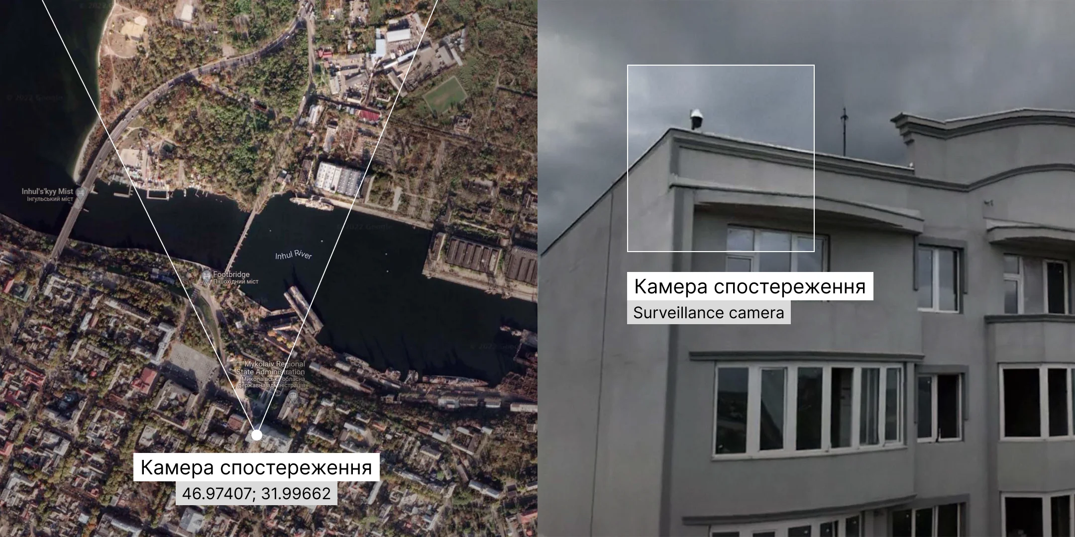
The video above is the only available footage capturing the missile that hit the Mykolaiv Regional State Administration building. It was recorded by a surveillance camera located on the roof of the “Admiral” housing complex across the street from the administration building. The camera view looks towards the northern districts of Mykolaiv.
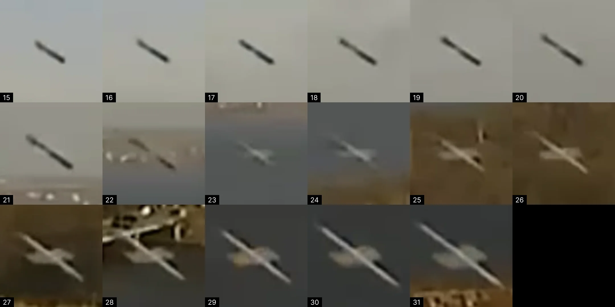
We placed a virtual camera within a 3d model of Mykolayiv to align its view with the surveillance camera. The Russian missile can be seen at the beginning of the video, between frames 14 and 32.
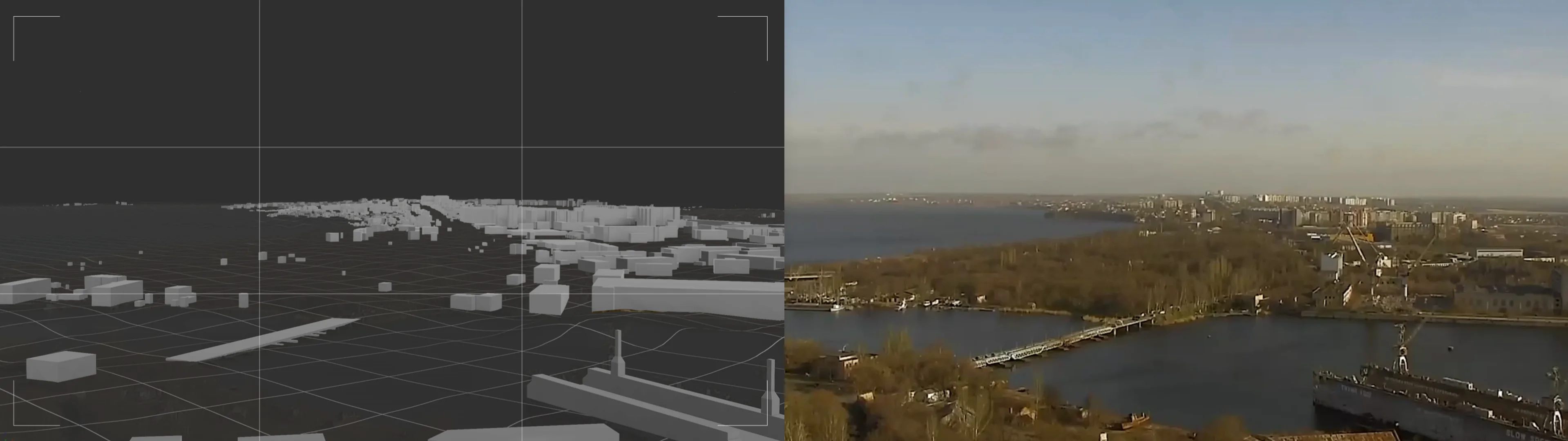

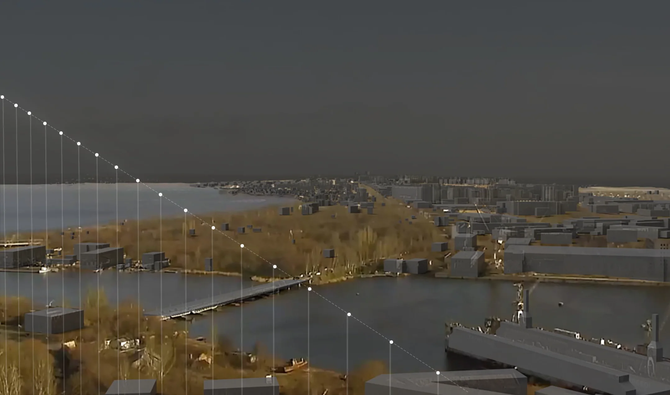
Knowing the camera's exact location and tracing the missile movement frame by frame, we established the exact trajectory angle in 3d space. This was done by drawing a plane perpendicular to the picture plane and finding a trajectory angle that would fit the perspective reduction on the video from the security camera.
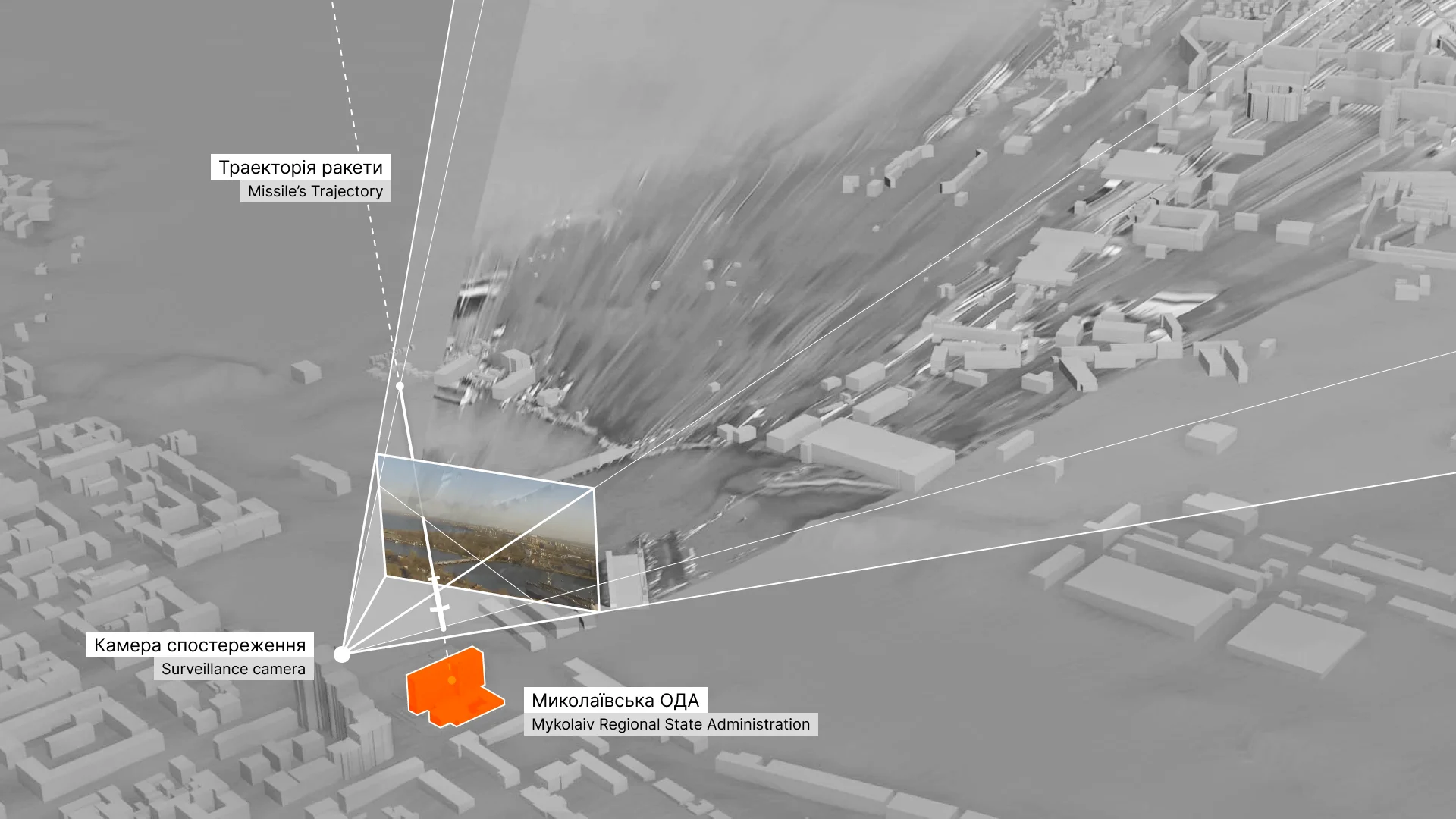
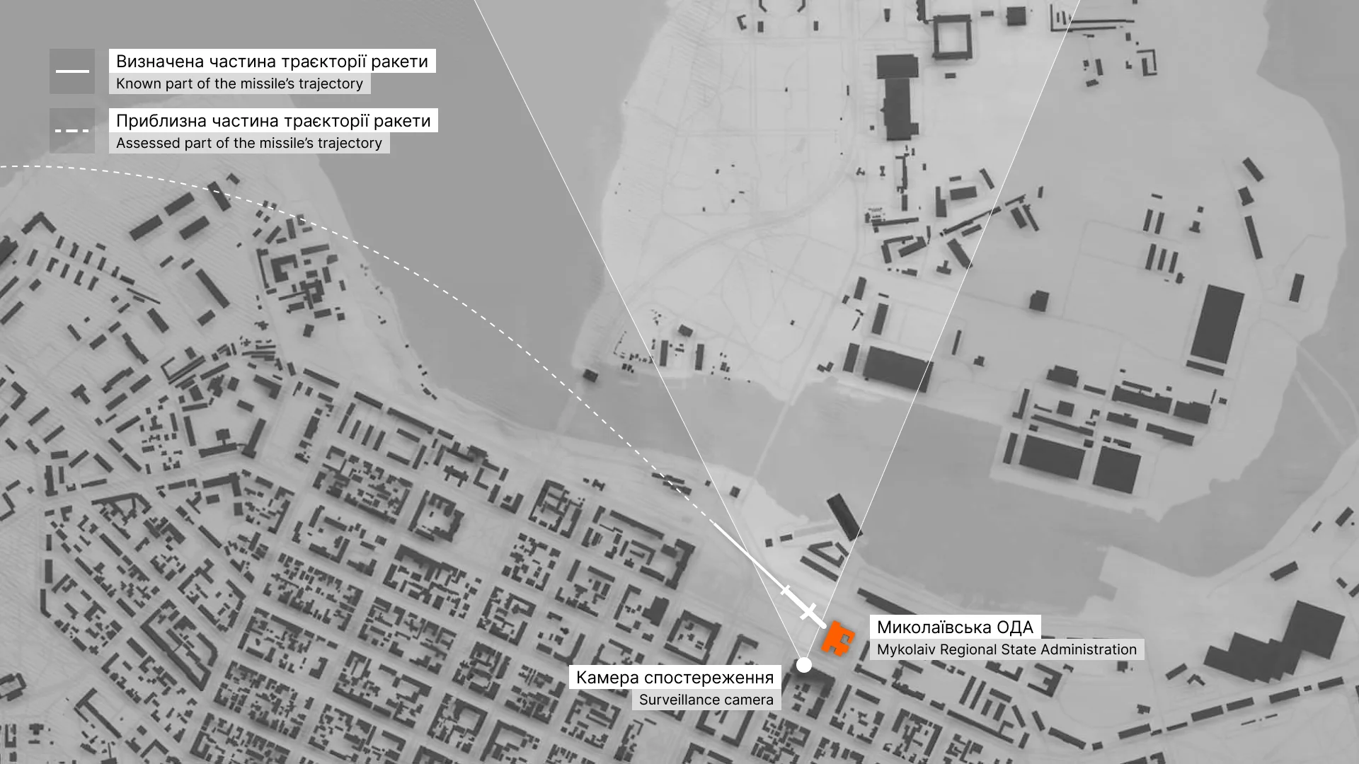
The Truth Hounds identified the missile as Kalibr 3M-14. This missile has a subsonic terminal speed of 0.8 Mach (approximately 275 m/s).
Using the 3d model of the environment with the established missile trajectory, we can now measure particular elements and/or quantities. For example, the distance between the missile’s nose cone on frame 14 and frame 31 is 170 meters. The video’s frame rate is 25 frames per second, which means that the missile passed the distance of 170 meters in 0.64 seconds, so its speed on this specific fragment of the trajectory was 266 m/s. This is close to the speed of the identified type of missile — 275 m/s (3.2% deviation).
Another way of identifying the missile’s type is to measure its length. Within the model, it is approximately 6.5 meters, while the spec length of Kalibr 3M-14 is 6.2 meters.
As a result of working with one video, we established the exact trajectory of the rocket in three-dimensional space and tested the hypothesis about the type of rocket by calculating its speed and size.
## Photogrammetry
We verified the correctness of the found missile’s trajectory with the help of a photogrammetrical scan of the affected building. It helped us to analyze the destruction of the concrete structure and then made it possible to establish the epicenter of the explosion. Comparing it with the results of previous calculations confirmed our conclusions.
Photogrammetry of the consequences of the Russian attack on the Mykolaiv Regional State Administration was made based on the Truth Hounds shooting. (Center of Spatial Technologies)
## Truth Hounds report
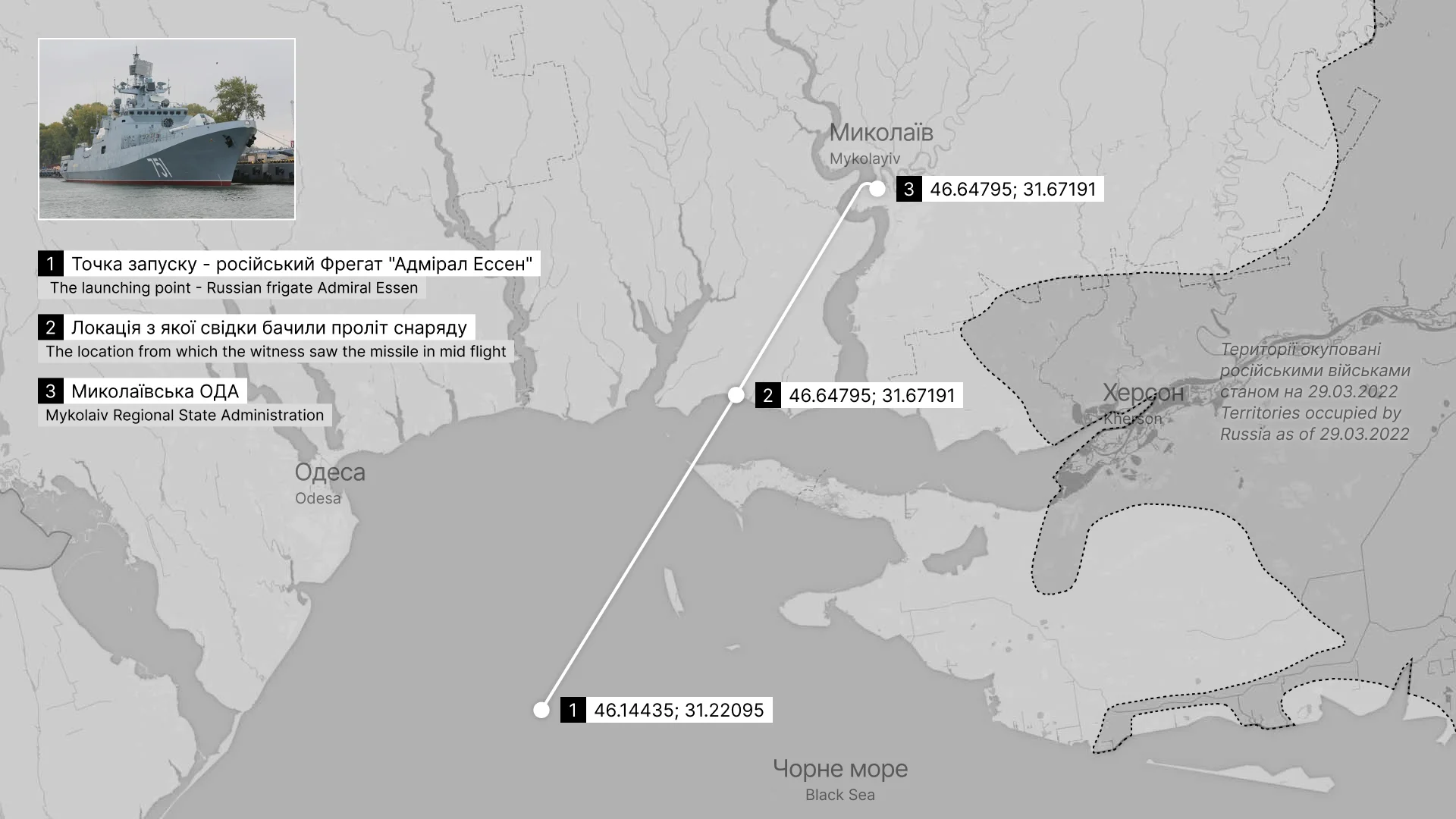
To learn where the Russian frigate Admiral Essen was located on March 29, 2022, as well as how we know that it was the exact 3M-14 missile launching point, and why this case can be qualified as a war crime — read the [Truth Hounds report](https://truth-hounds.org/en/cases/a-calibrated-crime/).
## Why attack Mykolaiv Regional State Administration?
The Truth Hounds report stated that the building of Mykolaiv Regional State Administration was used entirely for civilian purposes. At the moment of the attack, several members of the Territorial defense and military representatives were in the building for protection purposes. Why, then, did the Russians attack the building?
### Strategically important region
Mykolaiv is of paramount strategic importance: it is a crucial logistical hub (the city has Ukraine’s second-largest seaport, big river port, airport, and railway and highway hub) and Ukraine’s main shipbuilding center. Most of the Soviet Navy's surface ships (later inherited by the Russian Federation) were built in Mykolaiv, including its only aircraft carrier Kuznetsov, and the notorious battleship Moskva.
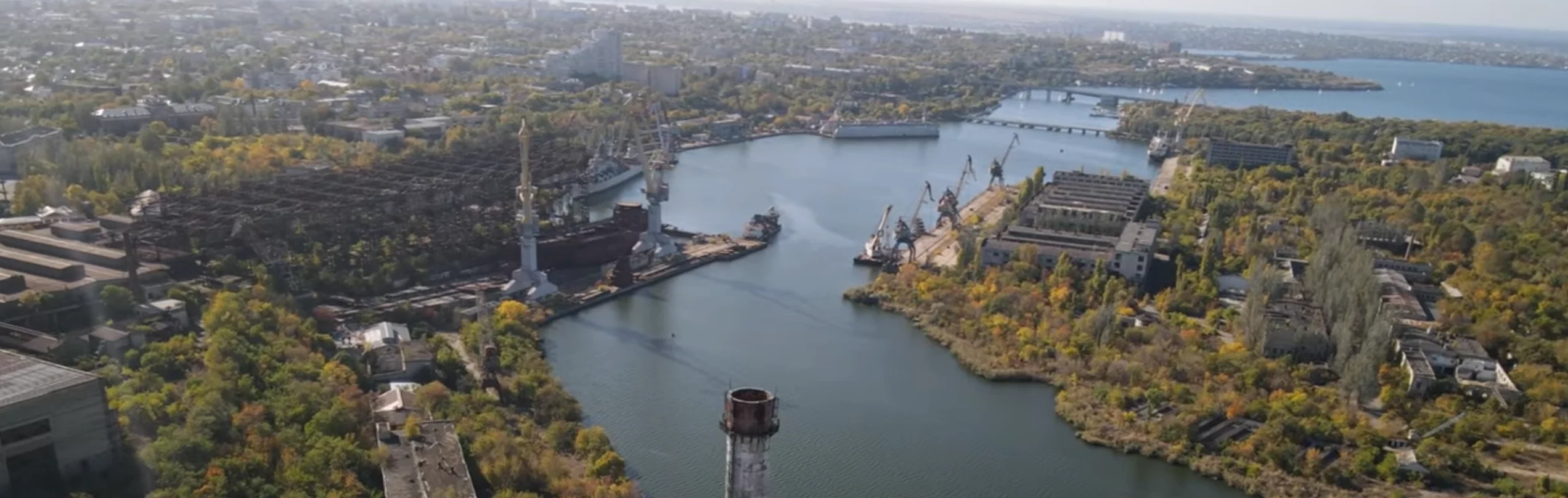

According to [The New York Times](https://www.nytimes.com/2022/03/06/world/europe/ukraine-beats-russia-mykolaiv.html) and [The Guardian](https://www.theguardian.com/world/2022/mar/04/russia-ukraine-mykolaiv-odesa-push-kyiv-fighting), Mykolaiv was one of the main targets of Russia during the first phase of its 2022 invasion of Ukraine. Mykolaiv’s capture would open the way to Odesa, and its control would allow the creation of a land corridor to Transnistria. By 29 March, however, Russia lost the [battle of Mykolaiv](https://en.wikipedia.org/wiki/Battle_of_Mykolaiv), having its forces pushed out of the border of the Mykolaiv region.

### The center of governance
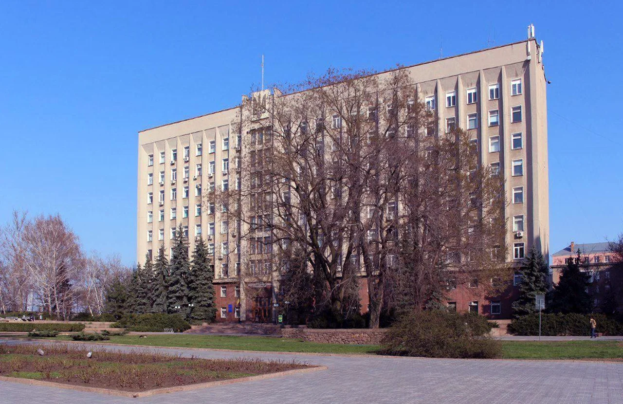
The Mykolaiv Regional State Administration building is the headquarters of local governance. The nine-story office building accommodated more than 100 government workers and the necessary equipment and communication networks.
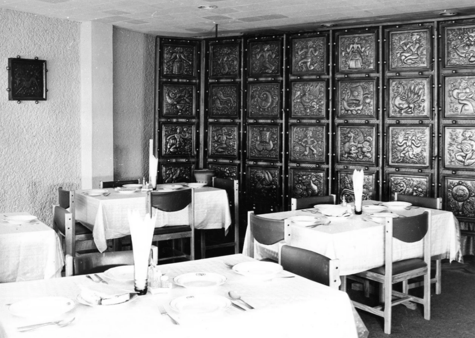
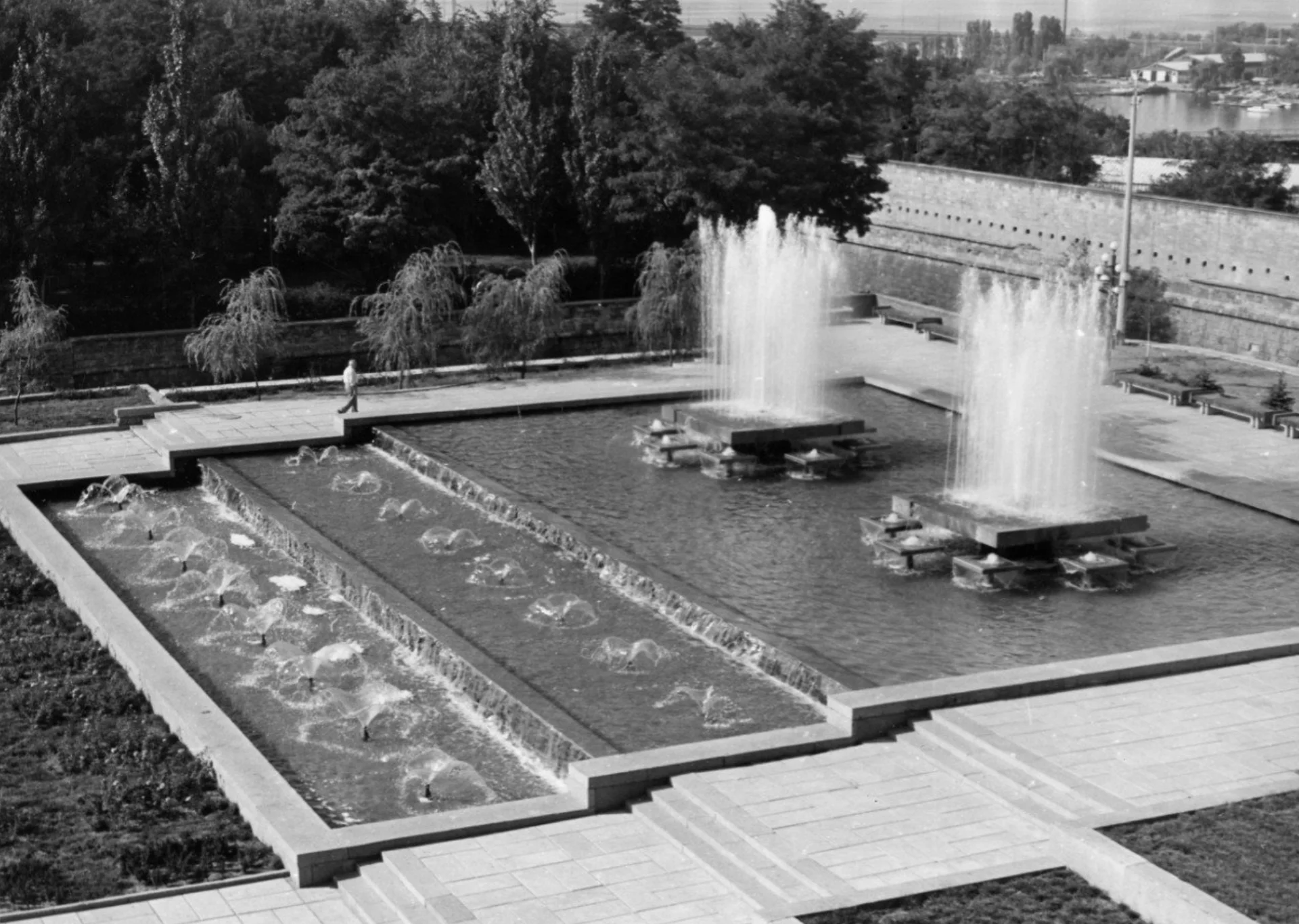
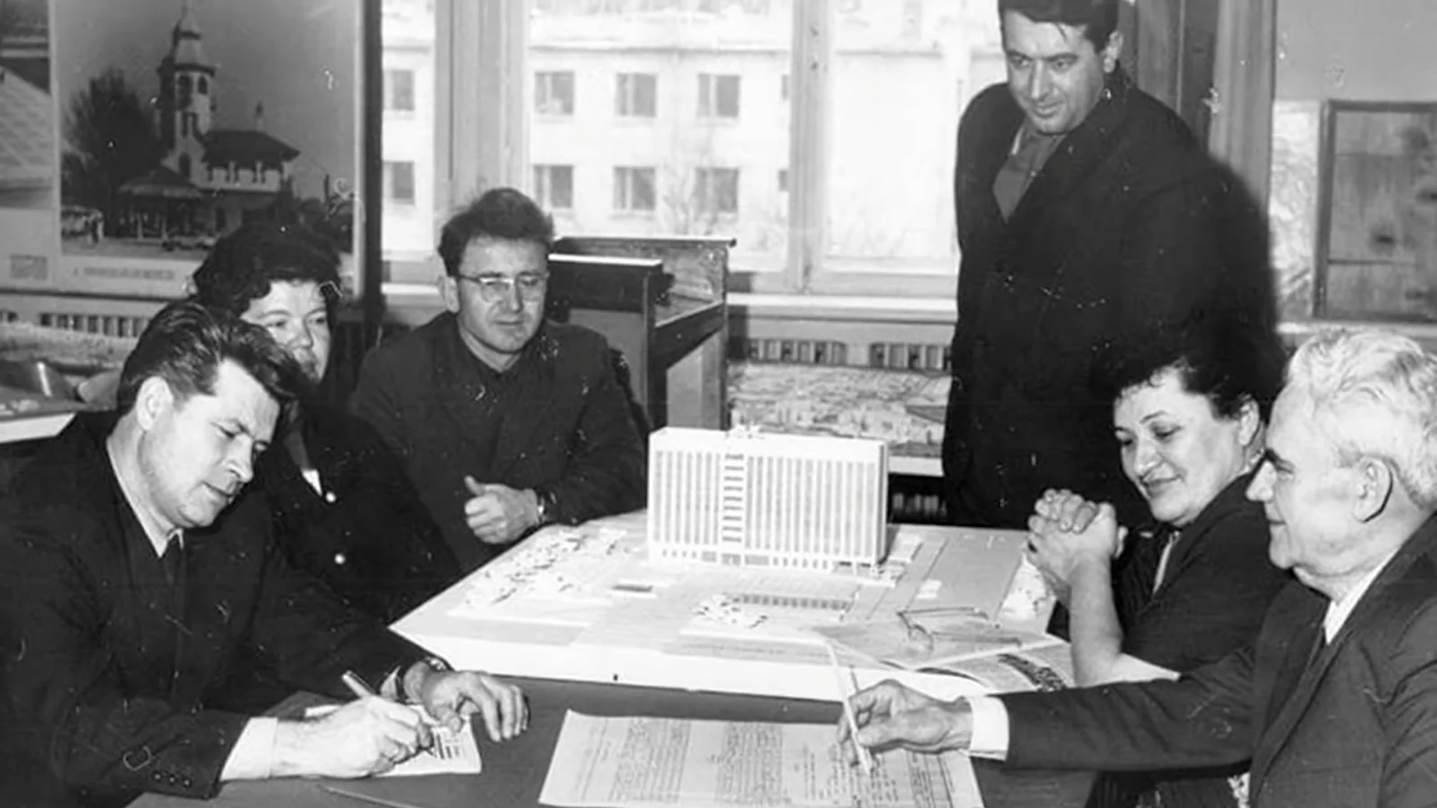
Designed by the architect Petro Kazmirchuk and constructed in 1981, the building stands in the heart of the city, framing a sequence of public spaces. The simple and recognizable modernist facade with the Ukrainian flag and trident (Ukrainian coat of arms) is directly associated with the state apparatus.
### Vitalii Kim
With the beginning of the full-scale invasion, Vitalii Kim, the head of Mykolaiv Regional State Administration and the Governor of Mykolaiv Oblast, became one of the most popular politicians in the Ukrainian Internet space, being associated with sincere openness and popular resistance. This makes him a significant target for the occupiers. On the day of the strike, Kim overslept and was late, saving his life. His secretary died because of the explosion.
![[collections/works/mykolaiv-oda/assets/images/vitalii-kim.png|Vitalii Kim, the Governor of Mykolaiv Oblast, in his office during the first days of the Russian invasion of Ukraine. ([Vitalii Kim / Mykolaiv Regional State Administration](https://t.me/mykolaivskaODA/523))]]
## Intention to weaken
One of Russia's goals in the war against Ukraine is its weakening. When the conquest of the new territories is impossible, it is necessary to weaken the opponent to reduce its development, resistance, and intensity of identity manifestation. It seems that the attack on the Mykolaiv Regional State Administration is based on precisely this logic because no valid military justifications for the attack have been found. Instead, it is obvious that the destruction of the local governance center and the assassination of the charismatic politician pursued the goal of weakening the strategically important region by violating the resistance processes and demoralizing the population.
Destruction of administrative buildings, cultural heritage, natural landscapes, infrastructure, industry, and, most importantly, human capital are proven mechanisms of imperial control. Ukrainian society is well aware of the nature of these mechanisms because it has had to deal with them systematically. You don't have to go far to remember this nature - the history of the place where the Regional State Administration building stands is full of examples of Moscow's imperial crimes.
## History of the place
The Mykolaiv Regional State Administration building and the surrounding public spaces are located on the site and have a rich historical background. Previously, the private indoor zoo founded by eccentric mayor Mykola Pavlovych Leontovych was located here. He collected a unique collection of aquariums by European standards equipped with electric compressors and heaters. In 1901, the building that accommodated three thousand liters of aquariums opened its doors to visitors.
In 1903, Mykola Pavlovych became a member of the City Duma, in 1906 - deputy mayor, and in 1908 - mayor of the city. In 1917, he was arrested for the first time by the order of workers' deputies; in 1937 - Leontovych was arrested for the second time on a number of trumped-up charges. He died in prison. When asked by the investigator why he did not flee abroad after the Bolshevik revolution, Leontovych answered that he could not leave the aquarium in which he had invested his whole life.
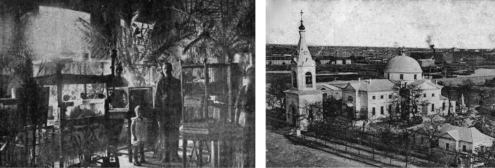
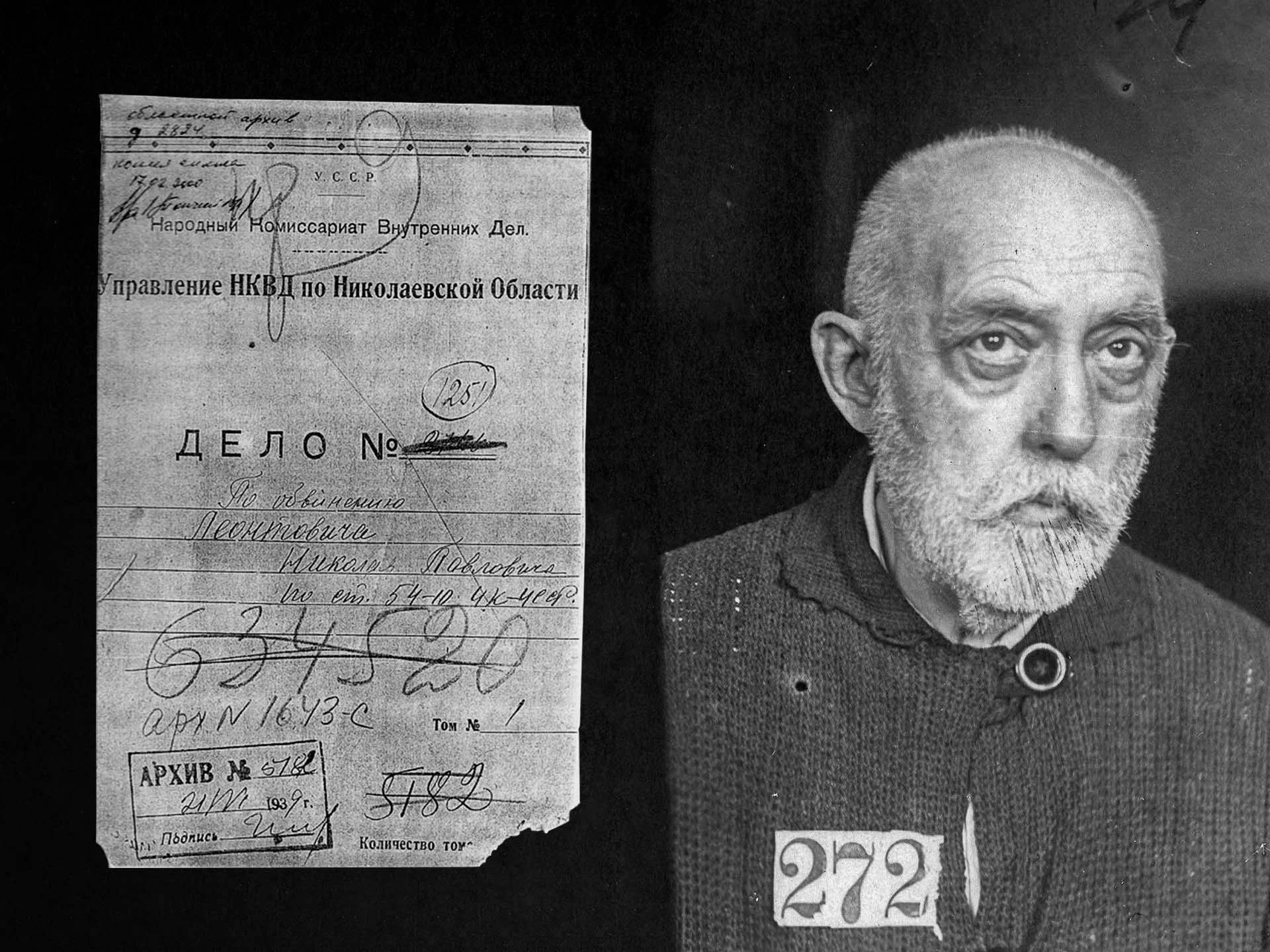
The historical symbol of the city — the Orthodox Church of St. Gregory the Great of Armenia- was built in 1794 by order of Grigory Potemkin and was located opposite the zoo on the neighboring block. Later it became the main temple of the Black Sea Fleet.
In 1923, the church was reformatted into the Ukrainian Cathedral. Later in 1929, the government decided to close it due to the ideological agenda of the Bolshevik authorities. However, the State Commission noted that the building was in good condition and was a great example of the "rare construction method of the end of the 18th century." Therefore, they decided to turn it into a museum building as a part of the Mykolaiv Historical and Archaeological Museum. All of the precious elements - bells, images, icons, etc were removed. The director of the museum, Feodosiy Kaminsky, tried to prevent the looting of church valuables, but this did not bring any results, except for the irritation of the Soviet leaders. The museum received the completely empty space of the former Cathedral; even the church bells were scrapped.
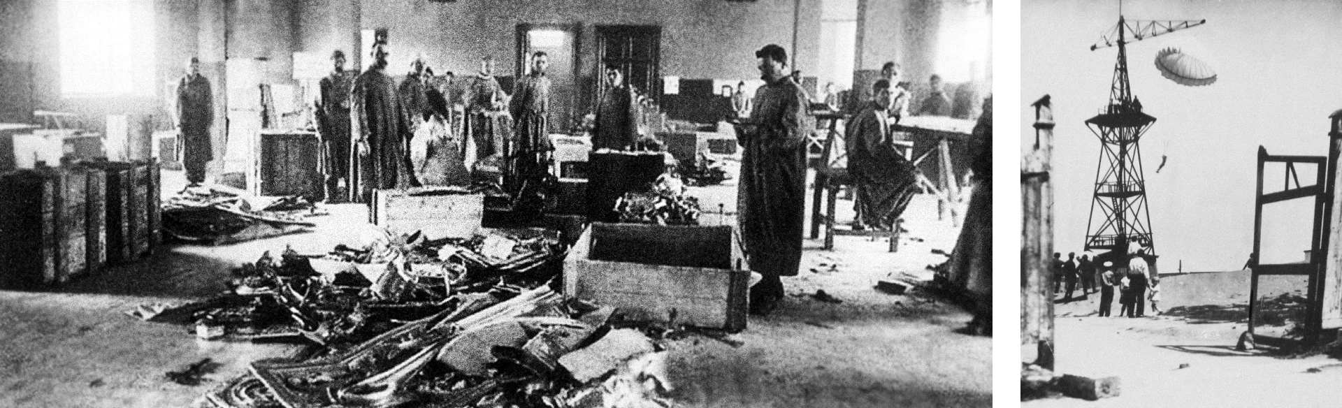
At the place where the church was located, a tower for parachute jumps was then built. Such activity was quite popular among young people at that time. In 1941, it was destroyed by the German invaders.
In 1927, one kilometer west of the building of the Mykolaiv Regional State Administration, in the very center of Mykolaiv, the Ukrainian archaeologist Feodosiy Kaminsky discovered an ancient port settlement — the city of the Cimmerian people. It is the oldest (1250-925 BC) mentioned in written sources settlement on the territory of Ukraine. In its heyday, the city combined the trade relations of the Cimmerians with the Greeks and Assyrians.
Kaminsky's archaeological find was ignored until the collapse of the Soviet Union. Then the excavations resumed after the disbandment of the military unit, which was based on the archaeological site.
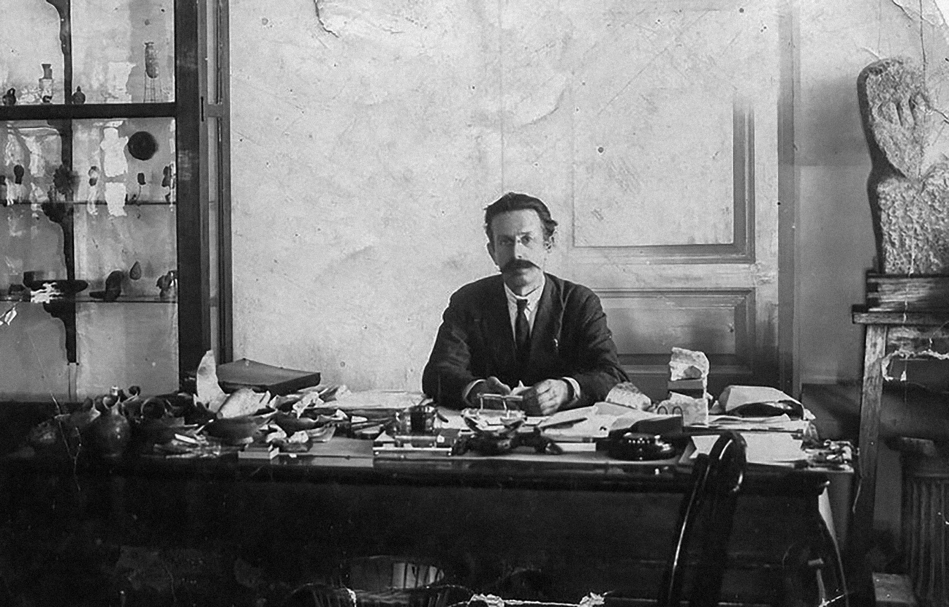
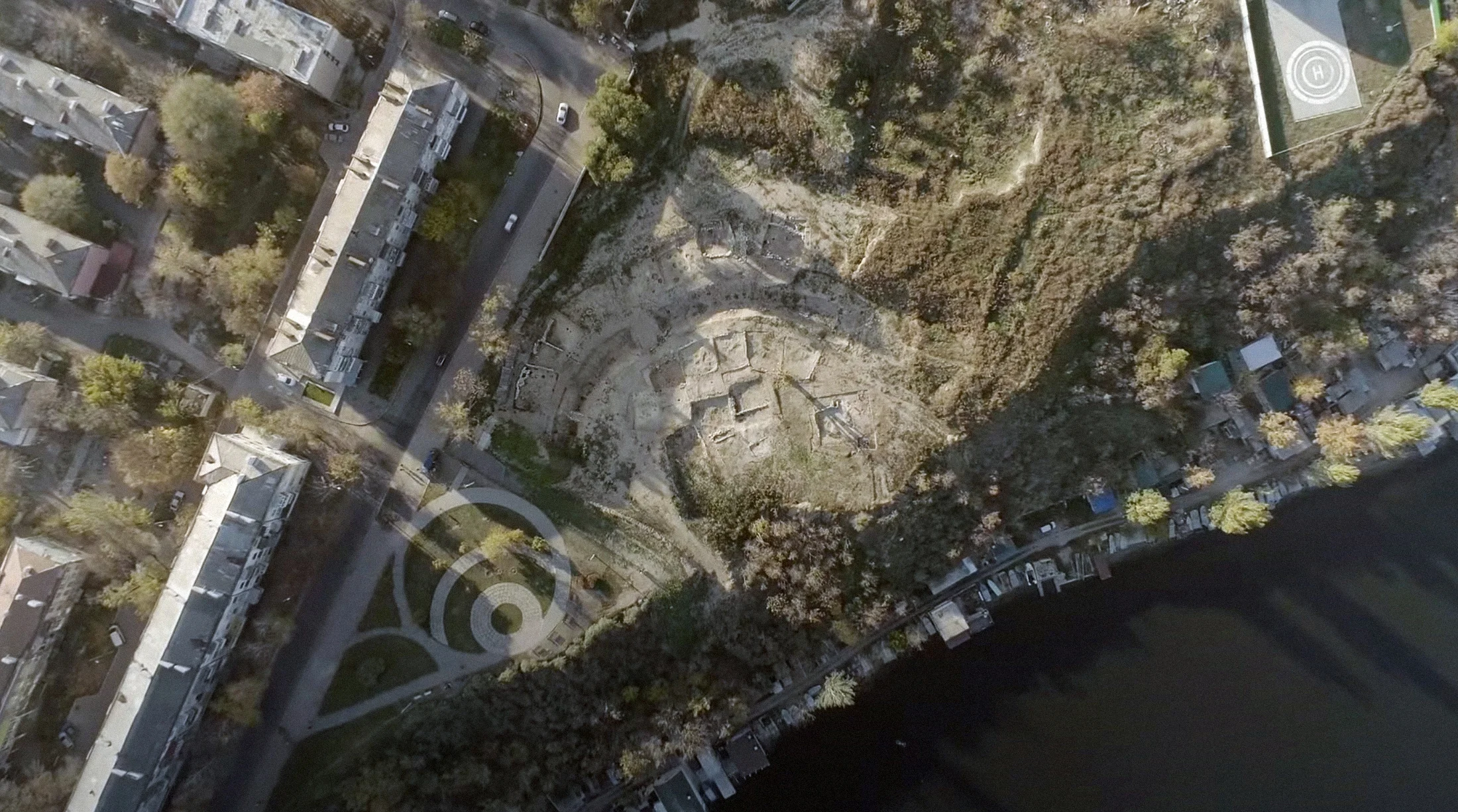
For his research and activism, Kaminsky was repressed by the Soviet authorities. In 1937, Feodosiy Timofiyovych was convicted for the third time. Overall, he spent 17 years in prison.
In 1937, when Mykola Leontovych and Feodosiy Kaminsky were once again imprisoned, and the city's Cathedral was blown up with dynamite, Ukrainian society was experiencing the peak of the Great Terror - the systematic Soviet repressions. It aimed to weaken, even suppress, the process of national revival, which threatened Sovietization, by destroying activists and centers of Ukrainian identity.
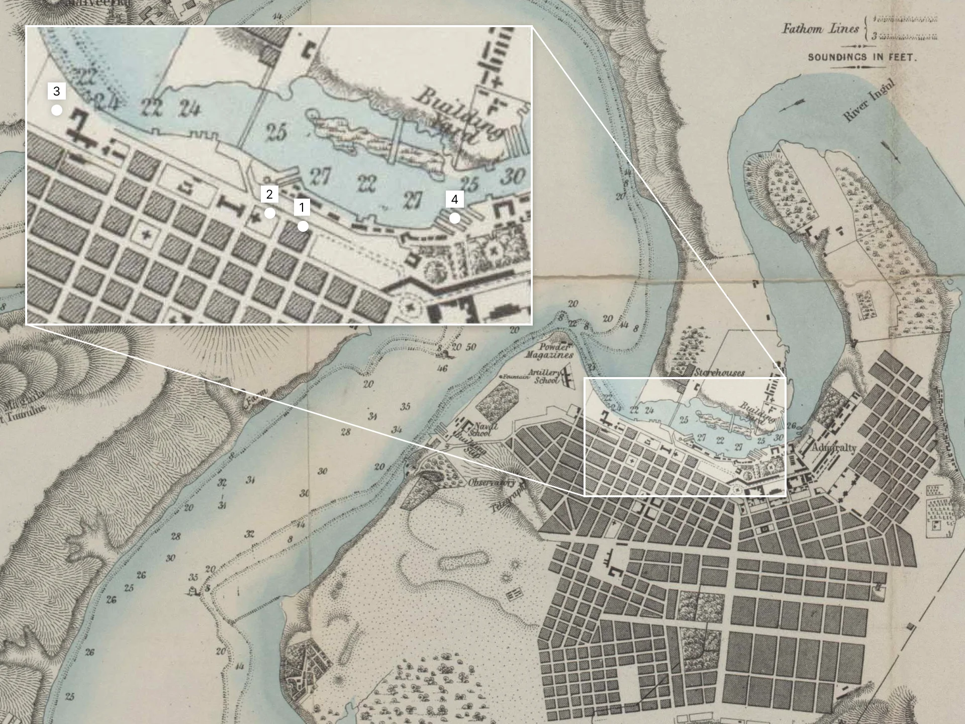
1. The Mykolaiv Regional State Administration is located in the historical city block.
2. The historical city block used to be occupied by the complex of the Orthodox Church of St. Gregory the Great of Armenia; now, the park is located there.
3. The site is where the remains of the ancient Cimmerian settlement were excavated in 1927.
4. Mykolaiv Shipyard. (Center for Spatial Technologies)
---
## Ракетний удар по Миколаївській ОДА
- URL: https://spatialtech.info/uk/works/mykolaiv-oda
- Language: Ukrainian
- Date: 2022-07-10T00:00:00.000Z
- Category: Цифровий проект реконструкції
29 березня 2022 року армія Російської Федерації завдала авіаудару по будівлі Миколаївської ОДА. У результаті цього загинуло 37 осіб, 34 отримали поранення. Ми долучилися до розслідування української правозахисної групи Truth Hounds, аби зрозуміти мету та соціокультурний контекст цієї атаки.

## Як багато інформації містить одне відео?
Відео вище — єдиний матеріал, на якому зафіксовано ракету, що влучила у будівлю Миколаївської обласної державної адміністрації. Його знято камерою спостереження з даху ЖК «Адмірал» навпроти адміністративної будівлі. Камера дивиться на північ, знімаючи райони міста: Темвод та Північний.
Замоделювавши ці райони Миколаєва, ми поставили віртуальну камеру в 3d моделі так, щоб вигляд з неї співпадав з виглядом з камери спостереження. Російську ракету можна побачити на початку відео, між кадрами 14 і 32.



Розташувавши камеру в 3d моделі та відслідкувавши рух ракети покадрово, ми встановили точний кут траєкторії польоту ракети. Це вдалося зробити після того, як ми накреслили площину, перпендикулярну до картинної площини, і підібрали кут лінії траєкторії так, щоб його відрізки підлягали перспективному скороченню відповідно до відео з камери спостереження.



Truth Hounds ідентифікували снаряд з відео як ракету типу Калібр 3M-14. Така ракета має дозвукову швидкість 0,8 Мах (приблизно 275 м/с).
Однією з переваг використання 3d моделі є можливість виконувати розрахунки. Відстань між головною частиною ракети на кадрі №14 та на кадрі №31 становить 170 метрів. Відео знято з кадровою частотою 25 кадрів на секунду. Значить ракета подолала дистанцію 170 метрів за 0,64 секунди, іншими словами її швидкість на цьому відрізку траєкторії — 266 м/с. Це близько до швидкості ідентифікованого типу ракети Калібр 3M-14 — 275 м/с (відхилення 3,2%).
Ще один параметр, за яким можна перевірити тип ракети — довжина. Для ракети типу Калібр 3M-14 вона має становити 6,2 метра, довжина на моделі — 6,5 метра. **
У результаті роботи з одним відео ми встановили точну траєкторію ракети у тривимірному просторі та перевірили гіпотезу щодо типу ракети за допомогою розрахунків її швидкості і довжини.

## Фотограметрія
Верифікувати коректність побудованої траєкторії польоту ракети нам вдалося за допомогою фотограметрії враженої будівлі. Аналіз руйнувань залізобетонної конструкції, який дозволяє зробити фотограметрія, дає змогу приблизно встановити епіцентр вибуху. Співставлення останнього з результатами попередніх розрахунків підтверджує зроблені висновки.
Фотограмметрія наслідків російської атаки на Миколаївську ОДА зроблена за матеріалами зйомок Truth Hounds. (Центр Просторових Технологій)
# Дослідження Truth Hounds
Про те, де знаходився російський фрегат «Адмірал Ессен» 29 березня 2022, звідки нам відомо, що саме звідти росіяни запустили ракету 3М-14, а також чому даний випадок має ознаки військового злочину, читайте у [звіті Truth Hounds](https://truth-hounds.org/cases/vidkalibrovanyj-zlochyn/).

# Навіщо завдавати удару по Миколаївській ОДА?
Розслідування Truth Hounds встановило, що будівля використовувалася суто як цивільний центр управління. На момент удару в ній знаходились декілька представників територіальної оборони та військових. Їх присутність була пов’язана з охороною приміщення адміністрації. Тоді якою могла бути мета атаки?
## Стратегічно важливий регіон
Миколаїв — стратегічно важливе українське місто. З одного боку, це ключовий логістичний вузол — місто має другий за величиною в Україні морський порт, великий річковий порт, аеропорт, залізнично-шляховий вузол. З іншого — головний суднобудівний центр України, — більшість надводних кораблів радянського флоту (пізніше успадкованих рф) були побудовані в Миколаєві, включно з єдиним радянським авіаносцем «Кузнєцов» і сумнозвісним ракетним крейсером «Москва».


Автори [The New York Times](https://www.nytimes.com/2022/03/06/world/europe/ukraine-beats-russia-mykolaiv.html) і [The Guardian](https://www.theguardian.com/world/2022/mar/04/russia-ukraine-mykolaiv-odesa-push-kyiv-fighting) зазначають, що Миколаїв був однією з головних цілей росії на початку її повномаштабного вторгнення в Україну. Окупація Миколаєва російською армією відкрила би їй шлях до Одеси та Придністров’я. Однак станом на 29 березня рф вже програла [битву за Миколаїв](https://uk.wikipedia.org/wiki/%D0%91%D0%BE%D1%97_%D0%B7%D0%B0_%D0%9C%D0%B8%D0%BA%D0%BE%D0%BB%D0%B0%D1%97%D0%B2) і відійшла за межі області.

### Центр управління
Обласна державна адміністрація — це центр управління областю. У дев’ятиповерховій офісній будівлі розміщувалися більше 100 державних службовиць_ців, а також необхідне обладнання та мережі зв’язку.
Зведена у 1981 році за проєктом архітектора Петра Казмірчука будівля ОДА стоїть у самому серці міста, обрамляючи низку центральних публічних просторів. Простий і впізнаваний модерністський фасад з українською символікою напряму асоціюється з державним апаратом.




### Віталій Кім
З початком повномасштабного вторгнення голова Миколаївської ОДА Віталій Кім став одим із найпопулярніших політиків в українському онлайн-просторі; символом відкритості та спротиву. Це імовірно робить його значимою для окупантів ціллю. У цей день Кім проспав і запізнився, це врятувало йому життя. Його секретарка загинула в результаті вибуху.

# Намір послабити
Однією з цілей росії у війні проти України є її ослаблення. Коли загарбати відразу не вдається, потрібно хоча би зробити опонента слабшим — зменшити силу розвитку, спротиву, інтенсивність прояву власної ідентичності. Схоже атака на Миколаївську ОДА вкладається саме в таку логіку, адже жодних вагомих військових обґрунтувань удару не виявлено. Натомість очевидно, що руйнування головного центру управління та вбивство харизматичного управлінця мало завдати шкоди процесам опору та деморалізувати населення, а отже послабити стратегічно важливий регіон.
Нищення управлінських будівель, культурної спадщини, природних ладшафтів, інфраструктури, промисловості, та головне — людського капіталу — це перевірені механізми реалізації імперського контролю. Українському суспільству має бути добре відома природа цих механізмів, адже йому не раз доводилося мати справу з ними. Аби пригадати цю природу далеко ходити не треба — історія місця, на якому стоїть ОДА, просякнута прикладами імперських злочинів москви.
# Історія місця
Споруда ОДА разом з навколишнім публічним простором стоїть на місці історичної забудови. Раніше тут знаходився приватний будинок-зоосад мера міста Миколи Павловича Леонтовича. У себе вдома він збирав унікальну для Європи колекцію акваріумів, оснащених електричними компресорами і нагрівачами. У 1901 році будинок Леонтовича з трьома тисячами літрів акваріумів відкрив свої двері для відвідувачів.
У 1903 році Микола Павлович став членом міської думи, у 1906 — заступником міського голови, а в 1908 — міським головою міста. У 1917 році був вперше заарештований за наказом робітничих депутатів, у 1937 вдруге — за низкою вигаданих обвинувачень. Помер в ув’язненні. На запитання слідчого про те, чому після революції не втік закордон, Леонтович відповів, що не зміг покинути акваріум, в який вклав все життя.


Навпроти будинку-зоосаду розташовувався історичний символ міста — православний храм святого Григорія Великої Вірменії, споруджений у 1794 році за наказом засновника Миколаєва Григорія Потьомкіна. Пізніше, після зміни влади у російській імперії, він став головним храмом імперського Чорноморського флоту.
1923 року храм було переформатовано в Український кафедральний собор. А вже у 1929 році його вирішили закрити з ідеологічних міркувань тогочасної більшовицької влади. Втім, Державна комісія відзначила, що будівля знаходилася в хорошому стані і була пам'яткою «рідкісної будівельної техніки кінця XVIII століття». Тому було прийняте рішення перетворити приміщення в музей і передати у підпорядкування Миколаївському історико-археологічному музею. Передати, але вилучивши попередньо всі дорогоцінні елементи церкви — дзвони, образи, ікони та інше. Директор музею Феодосій Камінський намагався завадити розграбуванню церковних цінностей, але окрім роздратування радянських керівників це ніякого результату не принесло. Приміщення собору дісталося музею абсолютно пустим, дзвони були здані на металобрухт.

В 1937 році собор було підірвано динамітом. На місці руїни спорудили вежу для популярних на той час серед молоді парашутних стрибків. У 1941 році і вона була зруйнована німецькими окупантами.
Феодосій Тимофійович Камінський, який керував історико-археологічним музеєм, відомий перш за все як визначний український археоолог. У 1927 році неподалік від місця, де сьогодні розташовується Миколаївська ОДА, він відкрив стародавнє місто-порт — Кіммерополіс, [місто людей кімерійських](https://uk.wikipedia.org/wiki/%D0%9C%D1%96%D1%81%D1%82%D0%BE_%D0%BB%D1%8E%D0%B4%D0%B5%D0%B9_%D0%BA%D1%96%D0%BC%D0%B5%D1%80%D1%96%D0%B9%D1%81%D1%8C%D0%BA%D0%B8%D1%85). Місто є найстарішим поселенням на території України, яке згадується в писемних джерелах (1250—925 років до н. е.). У часи свого розквіту воно поєднувало торгові зв'язки кімерійців з греками та ассирійцями.
Археологічна знахідка Камінського ігнорувалася до розпаду радянського союзу. Тоді розкопки поновилися після розформування військової частини, яка базувалась на місці археологічного майданчика.


За свою дослідницьку та активістську діяльність Камінський був репресований радянською владою. В 1937 рік, Феодосія Тимофійовича засудили втрєтє. В ув’язненні він прожив 17 років.
У 1937 році, коли Миколу Лентовича та Феодосія Камінського було в черговий раз ув’язнено, а центральний храм міста підірвано динамітом, українське суспільство переживало пік радянських репресій — великий терор. Він мав на меті ослабити, ба навіть придушити, процес національного відродження, який загрожував радянізації, шляхом знищення активних діячів_ок та осередків українськості.

Умовні позначення:
1. Історичний квартал забудови на місці сучасного ансамблю Миколаївської ОДА;
2. Історичний квартал зайнятий комплексом православного храму святого Григорія Великої Вірменії (пізніше - Адміралтейського собору); зараз на цьому місці - сквер ім. 68-и десантників та Вічний вогонь;
3. Місце, де в 1927 були відкриті залишки стародавнього міста Кіммерополіс;
4. Верф Миколаївського суднобудівного заводу.
(Центр Просторових Технологій)
---
## Networked Homes
- URL: https://spatialtech.info/en/works/networked-homes
- Language: English
- Date: 2021-01-06T00:00:00.000Z
- Category: Digital research project

Будівлі є розгалуженими мережами матеріальних і соціальних елементів, які об'єднуються у часі та просторі. Всі будівельні матеріали, кожен гвинт, мішок цементу чи вікно збираються з різних куточків планети. Формуючи та наповнюючи простір важливо розуміти, з яких елементів складається будівля, хто її створив, який її вплив на навколишнє середовище та хто отримає з неї прибуток. Погляд на простір крізь через розуміння того, що його компоненти конструюються та виробляються, дає можливість побачити його як живий організм. Елементи цього простору формують надточну інтерактивну модель, у якій між різними предметами виникають “діалоги”.
Через детальне вивчення простору та моделювання траєкторій, якими різні елементи рухаються від місця виробництва до місця використання ми намагаємося прослідкувати їхній соціальний та екологічний слід.


---
## Networked Homes
- URL: https://spatialtech.info/uk/works/networked-homes
- Language: Ukrainian
- Date: 2021-01-06T00:00:00.000Z
- Category: Цифровий дослідницький проект

Будівлі є розгалуженими мережами матеріальних і соціальних елементів, які об'єднуються у часі та просторі. Всі будівельні матеріали, кожен гвинт, мішок цементу чи вікно збираються з різних куточків планети. Формуючи та наповнюючи простір важливо розуміти, з яких елементів складається будівля, хто її створив, який її вплив на навколишнє середовище та хто отримає з неї прибуток. Погляд на простір крізь через розуміння того, що його компоненти конструюються та виробляються, дає можливість побачити його як живий організм. Елементи цього простору формують надточну інтерактивну модель, у якій між різними предметами виникають “діалоги”.
Через детальне вивчення простору та моделювання траєкторій, якими різні елементи рухаються від місця виробництва до місця використання ми намагаємося прослідкувати їхній соціальний та екологічний слід.


---
## Domestic Datascapes
- URL: https://spatialtech.info/en/works/domestic-datascapes
- Language: English
- Date: 2020-02-10T00:00:00.000Z
- Category: Video installation, Property tech

In 2018, so-called “PropTech” companies raised over $9.7B in funding, almost 500x the sector's worth in 2008. Technological transformations are increasingly affecting one of the world's most conservative and slow-moving industries - real estate. From listings and property management to algorithmic value assessment and trickier debt production mechanisms — these companies are changing the experience of domesticity.
The financialization of housing is gaining new momentum: the process of transforming housing into a commodity - a tool for enrichment and financial speculation - as opposed to housing as a social good.
The video work "Domestic Datascapes" seeks to understand the consequences of these technological changes by looking at the most personal domestic space through the lens of technological platforms.
Center for Spatial Technologies, for [“Eyes of the City” 2019 Bi-City Shenzhen Biennale of Urbanism\Architecture](https://eyesofthecity.net/domestic-datascapes/) curated by Carlo Ratti
---
## Domestic Datascapes
- URL: https://spatialtech.info/uk/works/domestic-datascapes
- Language: Ukrainian
- Date: 2020-02-10T00:00:00.000Z
- Category: Відеоінсталяція, Проперті технології

Консервативна та повільна індустрія нерухомості, стикається з хвилею технологічних зрушень. Технологічні компанії, які працюють з нерухомістю, у 2018 році залучили $9,7 млрд інвестицій. Це майже 500% зростання порівняно з $20 млн у 2008 році. Швидко зʼявляються нові способи взаємодії з домашнім простором — від розміщення обʼяв до оцінки вартості, кредитування, і інвестування з використанням штучного інтелекту. Нових обертів набирає _ʼфінанcіалізація’_ житла: процес перетворення житла в товар — інструмент збагачення і фінансової спекуляції — на противагу житлу як соціальному благу.
---
## Smart Commons
- URL: https://spatialtech.info/en/works/smart-commons
- Language: English
- Date: 2019-09-13T00:00:00.000Z
- Category: Data visualization, Cities
Public investment in shared infrastructure results in private profit through land value uplift – a problem that underpins our current model of urban development, fuelling land speculation and creating unequal and unsustainable neighborhoods. We need to redesign our land economy in a way that starts by recognizing public goods create private wealth.

In collaboration with [EIT Climate-KIC](https://www.climate-kic.org/) and [Dark Matter Labs](https://darkmatterlabs.org/) (DML), we are developing a platform that brings together smart contracts, property value data, and distributed ledgers to distribute this public value more fairly by creating a mechanism to invest in building more sustainable communities.
For more, read “[A Smart Commons: A New Model for Investing in the Commons](https://provocations.darkmatterlabs.org/a-smart-commons-528f4e53cec2)” on DML’s blog.
---
## Smart Commons
- URL: https://spatialtech.info/uk/works/smart-commons
- Language: Ukrainian
- Date: 2019-09-13T00:00:00.000Z
- Category: Візуалізація даних, Міста
Публічні інвестиції в інфраструктуру призводять до зростання вартості приватних активів. Держава будує нову гілку метро — нерухомість, яка здебільшого перебуває у приватній власності дорожчає. Саме ця проблема лежить в основі нинішніх політик міського розвитку, сприяючи спекуляції та нерівності.

У співпраці з [EIT Climate-KIC](https://www.climate-kic.org/) та [Dark Matter Labs](https://darkmatterlabs.org/) (DML), ми розробили пропозицію альтернативної моделі для створення більш сталих громад. Базується така модель на оцінці зростання вартості активів внаслідок побудови інфраструктурних об’єктів — і використання розумного механізму перерозподілу цієї цінності (оподаткування) для фінансування побудови публічної інфраструктури.
Читайте детальніше про проєкт: “[A Smart Commons: A New Model for Investing in the Commons](https://provocations.darkmatterlabs.org/a-smart-commons-528f4e53cec2)”.